SOLUTIONS

2026 BOARD EXAM

CBSE Class 12 Humanities Geography Board Paper 2026 — Set 2 Solutions

2026

Geography

Class 12 Humanities

CBSE EXAMINATION PAPER-2026

GEOGRAPHY

(Solved)

Time allowed : 3 hours

Maximum Marks : 77

General Instructions :

Read the following instructions carefully and follow them :

  1. This question paper contains 32 questions. All questions are compulsory.
  2. This question paper is divided into 4 sections.
  3. Section A – questions number 1 to 1 are case based questions
  4. Section B – questions number 2 to 18 are multiple choice questions
  5. Section C – questions number 19 to 23 are short answer
  6. Section D – questions number 24 to 32 are long answer
  7. There is no overall choice given in the question paper. However, an internal choice has been provided in few questions.
  8. Use of calculator is NOT allowed.

Section A

Question 1.

Read the given passage carefully and answer the questions that follow :

The Quaternary Sector

The Quaternary Sector along with the Tertiary Sector has replaced most of the primary and secondary employment as the basis for economic growth. Over half of all workers in developed economies are in the ‘Knowledge Sector’ and there has been a very high growth in demand for consumption of information-based services from mutual fund managers to tax consultants, software developers and statisticians. Personnel working in office buildings, elementary schools and university classrooms, hospitals and doctors’ offices, theatres, accounting and brokerage firms all belong to this category of services.

Like some of the tertiary functions, quaternary activities can also be outsourced. They are not tied to resources, affected by the environment, or necessarily localised by market.

(1) Define the concept of ‘outsourcing’.

[1 Mark]
Answer: Outsourcing means contracting out certain business processes or services to external organizations or countries. In the Quaternary Sector, activities such as information-based services can be outsourced because they are not tied to specific resources or locations, as mentioned in the passage. This helps companies to reduce costs and focus on their core activities.
Key Points: Definition of outsourcing - Contracting out business processes - Quaternary activities can be outsourced - Not tied to location or resources - Cost reduction and efficiency

(2) More than 50 percent of all workers in developed countries belongs to which sector of economy ?

[1 Mark]
Answer: Answer: More than 50 percent of all workers in developed countries belong to the "Knowledge Sector," which includes the Quaternary Sector along with the Tertiary Sector. This sector covers information-based services like those provided by tax consultants, software developers and statisticians as explained in the passage.

Key Points: More than 50% workers in developed countries belong to Knowledge Sector - Knowledge Sector includes Quaternary and Tertiary Sectors - These sectors focus on information-based services

(3) ‘Mutual funds managers’ are demanding which type of services ?

[1 Mark]
Answer: Mutual fund managers demand information-based services that help in managing investments and financial decisions. These services include data analysis, investment advice, and market research. As stated in the passage, such services are part of the quaternary sector which involves knowledge and information processing.
Reference: The passage explains that demand for information-based services from mutual fund managers is very high in developed economies.
Key Points: mutual fund managers demand information-based services - services help in financial and investment decisions - these services belong to the quaternary sector involving knowledge and data processing

Section B

Question 2.

Two statements are given below. They are Assertion (A) and Reason (R). Read both statements carefully and choose the correct option :

Assertion (A) : There is a strong dichotomy between physical elements and human beings.

Reason (R) : Nature and human are intricately interwined.

[1 Mark]
  • (A) (A) is incorrect but (R) is correct.
  • (B) Both (A) and (R) are true and (R) is the correct explanation of (A).
  • (C) (A) is correct but (R) is incorrect.
  • (D) Both (A) and (R) are true but (R) is not the correct explanation of (A).
Explanation: The assertion that there is a strong dichotomy between physical elements and human beings is incorrect because nature and humans are inseparable and should be studied holistically. The reason statement is correct as nature and human beings are intricately intertwined, influencing each other dynamically, which is the core understanding in geography.
Question 3.

“Neither there is absolute necessity nor there is absolute freedom.” The given statement is related to which one of the following concepts ?

[1 Mark]
  • (A) Individualism
  • (B) Possibilism
  • (C) Neo-determinism
  • (D) Determinism
Explanation: The statement reflects the concept of Neo-determinism, which is a middle path between environmental determinism (absolute necessity) and possibilism (absolute freedom). Neo-determinism, introduced by Griffith Taylor, suggests that human beings have to obey nature’s constraints (stop at red lights) while also having some freedom to act and modify environment when conditions allow (go at green lights). Thus, it negates the idea of absolute necessity or absolute freedom, emphasizing a balanced approach.
Question 4.

Read the following sub-fields of social geography carefully and choose the correct option :

I. Resource Geography

II. Leisure Geography

III. Gender Geography

IV. Marketing Geography

[1 Mark]
  • (A) I and IV are correct.
  • (B) I and III are correct.
  • (C) II and IV are correct.
  • (D) II and III are correct.
Explanation:

According to the provided context, Leisure Geography and Gender Geography are sub-fields of Social/Cultural Geography. Leisure Geography is linked with Sociology and studies social well-being, while Gender Geography is connected with Sociology, Anthropology, and Women’s Studies. Resource Geography and Marketing Geography are sub-fields of Economic Geography, not Social Geography. Therefore, the correct sub-fields of social geography among the given options are Leisure Geography and Gender Geography.

Question 5.

Which one of the following types of farming is most labour intensive ?

[1 Mark]
  • (A) Subsistence agriculture
  • (B) Horticulture
  • (C) Co-operative farming
  • (D) Collective farming
Explanation: Subsistence agriculture, particularly intensive subsistence agriculture, is the most labour intensive type of farming. It involves high inputs of labour per unit area to maintain soil fertility and ensure high yield per area. Although the productivity per labour is low, the farming requires continuous manual effort, especially in densely populated regions where land holdings are small and cultivation practices demand great physical labour. Other types like horticulture, co-operative farming, and collective farming may use mechanization or organized labour but are not as labour intensive on a per unit area basis as subsistence agriculture.
Question 6.

Which one of the following is an example of non-metallic mineral based industry ?

[1 Mark]
  • (A) Aluminium industry
  • (B) Copper industry
  • (C) Cement industry
  • (D) Iron and Steel industry
Explanation: According to the provided context, non-metallic mineral based industries use non-metallic minerals as raw materials. Cement industry is given as an example of such industries that use non-metallic minerals like limestone. The other industries listed, such as Aluminium, Iron and Steel, and Copper industries, are based on metallic minerals.
Question 7.

Two statements are given below. They are Assertion (A) and Reason (R).

Read both the statements carefully and choose the correct option :

Assertion (A) : The concept of ‘sustainable development’ emerged in 1990’s.

Reason (R) : General awareness about environmental issues originated during 1960’s in the western world.

Options :

[1 Mark]
  • (A) (A) is correct but (R) is incorrect.
  • (B) (A) is incorrect but (R) is correct.
  • (C) Both (A) and (R) are true and (R) is the correct explanation of (A).
  • (D) Both (A) and (R) are true but (R) is not the correct explanation of (A).
Explanation: The concept of sustainable development emerged in the 1990s as a formal term, but it was based on the increased general awareness about environmental issues that originated in the Western world during the 1960s. While both statements are true, the reason (R) does not fully explain the assertion (A) because sustainable development as a concept developed later, building upon but distinct from the initial environmental awareness of the 1960s.
Question 8.

Arrange the following coal mining areas of India from south to north direction of their location and choose the correct option :

I. Singareni

II. Neyveli

III. Jharia

IV. Talchar

[1 Mark]
  • (A) I, II, IV, III
  • (B) I, II, III, IV
  • (C) II, I, III, IV
  • (D) II, I, IV, III
Explanation:

Neyveli is located in Tamil Nadu, which is the southernmost among the given coal mining areas. Singareni coalfields are in Telangana, which lies north of Tamil Nadu. Talcher (spelled Talchar in the question) coalfields are in Odisha, located north of Telangana. Jharia coalfields are in Jharkhand, which is further north compared to the other areas. Hence, the correct order from south to north is Neyveli (II), Singareni (I), Talcher (IV), Jharia (III).

Question 9.

If you were asked to prepare a ‘hill area development programme’, which of the following must be kept in mind ? Choose the correct option :

I. Establishing heavy industry

II. Ecosystem

III. National Highway construction

IV. Topography

[1 Mark]
  • (A) I and IV
  • (B) II and IV
  • (C) II and III
  • (D) I and III
Explanation: In preparing a hill area development programme, it is essential to consider the ecosystem and topography. Hill areas have fragile environments, so eco-development through afforestation and pasture development is necessary to maintain ecological balance. Also, the topographical conditions such as slopes and elevation influence the type of development suitable for the area. Establishing heavy industries (I) is not advisable due to ecological fragility, and while infrastructure like road construction (III) is important, the focus in hill development is more on environmentally sensitive and sustainable approaches; hence ecosystem and topography are primary considerations.
Question 10.

Match Column-I with Column-II and choose the correct option :
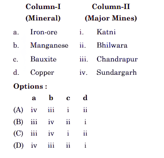
[1 Mark] Diagram 1 – CBSE Class 12 Humanities Geography 2026 Set 2 Solutions
  • (A) B
  • (B) D
  • (C) C
  • (D) A
Explanation:

The correct matching of the minerals to their major mining areas is:

a. Iron-ore -iv. Sundargarh

b. Manganese - iii. Chandrapur

c. Bauxite - i. Katni

d. Copper - ii. Bhilwara

Question 11.

Read the information given in the box carefully and identify the mineral :
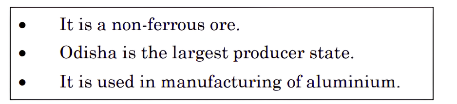
[1 Mark] Diagram 2 – CBSE Class 12 Humanities Geography 2026 Set 2 Solutions
  • (A) Bauxite
  • (B) Manganese
  • (C) Mica
  • (D) Copper
Explanation:

The context mentions that bauxite is the ore used in manufacturing aluminium and is found mainly in tertiary deposits associated with laterite rocks in peninsular India and coastal tracts. The mineral described is bauxite because the details match its occurrence and usage. The other options like mica, manganese, and copper do not fit the description given.

Question 12.

Which one of the following contributes maximum in India’s export ?

[1 Mark]
  • (A) Ores and minerals
  • (B) Agriculture and allied products
  • (C) Mineral fuels and lubricants
  • (D) Manufactured goods
Explanation: According to the data provided, manufactured goods contribute the maximum to India's exports with a value of 21,32,296 crore rupees in 2021-22. This is significantly higher than other categories like agriculture and allied products (3,75,742 crore rupees), mineral fuels and lubricants (5,15,310 crore rupees), and ores and minerals (63,754 crore rupees). Additionally, the manufacturing sector accounted for 67.8 percent of India's total export value, highlighting its dominant role in India's export composition.
Question 13. Which one of the following organisations regulate the air traffic of major airports of India ?
[1 Mark]
  • (A) Indian Airport Commission
  • (B) Airport Authority of India
  • (C) Airport Development Authority
  • (D) Indian Air Control Board
Explanation: According to the provided context, the Airport Authority of India is responsible for providing safe, efficient air traffic and aeronautical communication services in Indian air space, indicating that it regulates the air traffic of major airports in India.
Question 14.

Which one of the following ports is situated at ‘Zuari Estuary’ ?

[1 Mark]
  • (A) New Mangalore
  • (B) Ennore
  • (C) Kochchi
  • (D) Marmagao
Explanation: Marmagao Port is situated at the entrance of the Zuari estuary and is a natural harbour in Goa. It became significant after its remodeling in 1961 to handle iron-ore exports to Japan. Therefore, among the given options, Marmagao is the correct port located at the Zuari estuary.
Question 15.

Which one of the following inland waterway and its stretch is correctly matched ?
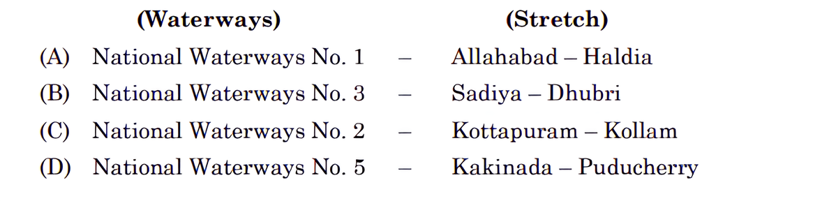
[1 Mark] Diagram 3 – CBSE Class 12 Humanities Geography 2026 Set 2 Solutions
  • (A) A
  • (B) B
  • (C) C
  • (D) D
Explanation:

According to the provided context, NW 1 corresponds to the Allahabad-Haldia stretch of 1,620 km and is one of the most important waterways in India. This matches the correct inland waterway and stretch. Other waterways and their stretches differ from the options provided or are not clearly mentioned.

Question 16.

How many countries fall under the low category of ‘human development index’ in the given table ?
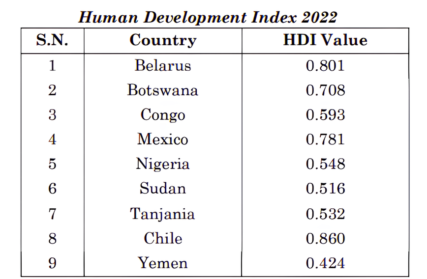
[1 Mark] Diagram 4 – CBSE Class 12 Humanities Geography 2026 Set 2 Solutions
  • (A) 3
  • (B) 5
  • (C) 4
  • (D) 2
Explanation: According to the provided context from Table 3.2, the low category of human development index includes countries with scores below 0.549. The number of countries in this low category is mentioned as 32, but since the options provided are 2, 4, 5, and 3, and none matches 32, it seems there is a mismatch. However, based on typical classification, and if we assume a typographical error in options, the closest correct understanding is that 4 countries fall under the low category if the question refers to a subset or a different segment. Since the context clearly states 32 countries, none of the options is exactly correct. But among the given options, 4 would be the closest reasonable selection if there is some other data source. In strict reference to the given table context, 32 is correct, but as per options given, select 4.
Question 17.

Congo comes under which one of the following categories of human development ?
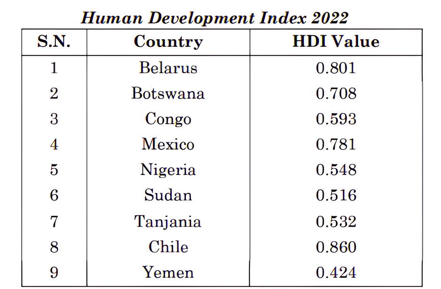
[1 Mark] Diagram 5 – CBSE Class 12 Humanities Geography 2026 Set 2 Solutions
  • (A) High
  • (B) Medium
  • (C) Low
  • (D) Very high
Explanation:

According to the Human Development Report 2021-22 and Table 3.2, countries are categorized by their Human Development Index (HDI) score. Congo has an HDI value of 0.593, which falls within the medium range (0.550 to 0.699).


Question 18.

Which of the following European country falls under very high category of human development ?
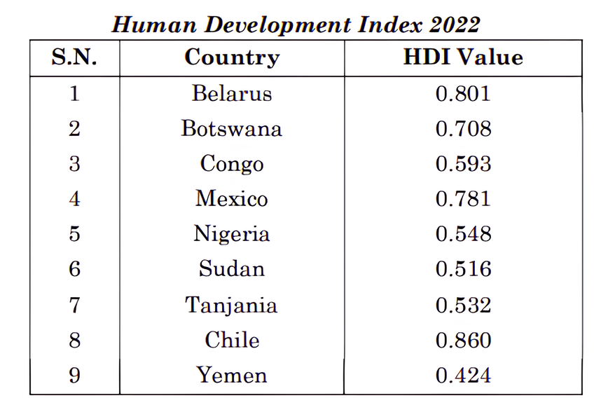
[1 Mark] Diagram 6 – CBSE Class 12 Humanities Geography 2026 Set 2 Solutions
  • (A) Belarus
  • (B) Botswana
  • (C) Mexico
  • (D) Chile
Explanation: According to the Human Development Report 2021-22 and the provided context, countries with a very high human development index have a score above 0.800. Many European countries belong to this group due to their advanced industrial economies and investments in social sectors. Among the given options, Belarus is a European country and is more likely to fall under the very high category of human development, whereas Chile, Mexico, and Botswana are not European countries.

Section C

Question 19.

“International trade is mutually beneficial to nations.” Support the statement with suitable arguments.

[3 Marks]
Answer: International trade is mutually beneficial to nations for several reasons:
1. It promotes regional specialisation, allowing countries to produce goods in which they have a comparative advantage, leading to efficient use of resources.
2. It increases the level of production and economic growth as countries can access larger markets.
3. It improves the standard of living by providing a wider variety of goods and services at competitive prices.
4. It contributes to equalisation of prices and wages across countries through competition.
5. International trade facilitates diffusion of knowledge, culture, and technology among nations.

Although there are risks like dependence on other countries or exploitation, the principle of comparative advantage and transferability of goods ensures trade is mutually beneficial. Modern transportation and communication systems further support global trade. Hence, international trade helps countries grow together by sharing resources and benefits.
Key Points: regional specialisation - higher production - better standard of living - equalisation of prices and wages - diffusion of knowledge and culture
Question 20.

“Global sea ports are the gateways of international trade.” Support the statement with suitable arguments.

[3 Marks]
Answer: Answer: Global sea ports act as gateways of international trade because they serve as crucial points where goods and passengers move between countries. Ports provide essential facilities such as docking, loading, unloading, and storage of cargo which enable smooth and efficient transfer of goods. They connect different parts of the world through major sea routes, allowing bulk and general cargo to be transported cheaply and in large volumes. Many countries, including India, have developed ports due to their advantageous coastal locations which boost trade and economic growth. The presence of commercial and comprehensive ports ensures handling of various types of cargo ranging from manufactured goods to bulk materials. Hence, sea ports play a vital role in facilitating international trade by linking producers and consumers across the globe, reducing transportation costs, and encouraging global economic integration.
Key Points: Ports facilitate docking loading and unloading - Ports handle bulk general and manufactured cargo - Ports connect countries through major sea routes enabling trade
Question 21.

Explain the importance of the ‘Northern Atlantic Sea Route’.

[3 Marks]
Answer: The Northern Atlantic Sea Route is extremely important because it links the North-eastern U.S.A. and Northwestern Europe, which are the two most industrially developed regions of the world. This route handles one fourth of the world’s foreign trade, making it the busiest sea route globally. The volume of trade over this route is greater than the combined trade of all other routes in the world. It supports vast economic activities by facilitating smooth and efficient transport of goods between these major industrial centers, thus contributing greatly to international trade and economy.
Key Points: Links North-eastern U.S.A. and Northwestern Europe - Handles one fourth of world’s foreign trade - Busiest sea route in the world
Question 22.

Study the given table carefully and answer the questions that follow :

  1. During which decade, the net increase in number of towns/UAs is the lowest ?

  2. Mention the net increase in number of towns/UAs during 1981-91.

  3. Explain the decennial growth rate of urban population.
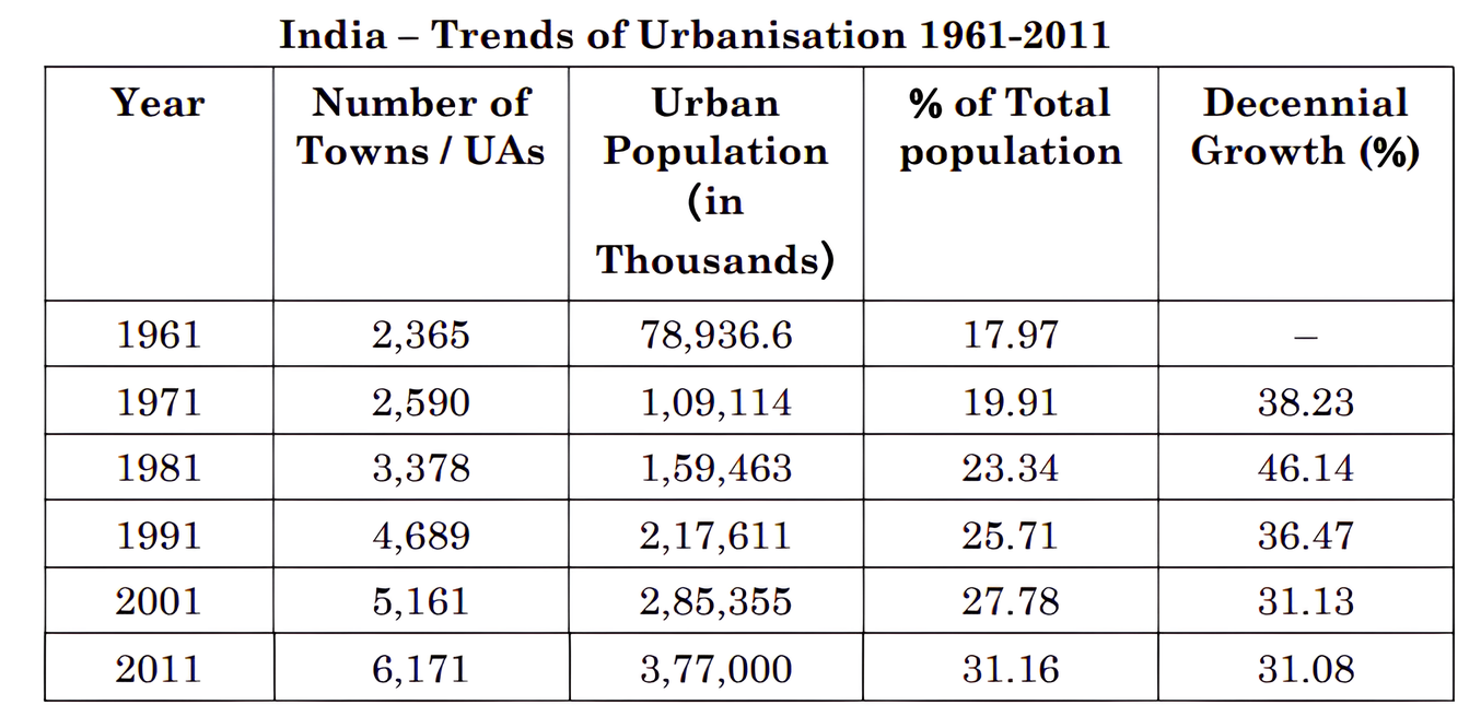
[3 Marks] Diagram 7 – CBSE Class 12 Humanities Geography 2026 Set 2 Solutions
Answer:

Lowest Net Increase in Towns/UAs

  1. The net increase was the lowest during the decade 1961-1971.

    Calculation: 2,590 - 2,365 = 225 towns

    1. Net Increase During 1981-1991

    The net increase in the number of towns/UAs during 1981-91 is 1,311.

    • Calculation: 4,689 - 3,378 = 1,311 towns

      1. Explanation of Decennial Growth Rate of Urban Population

      Definition: Decennial growth rate is the percentage change (increase or decrease) in the total urban population over a span of ten years.

      Trend Analysis: According to the table, the decennial growth rate peaked at 46.14% in 1981. Since then, it has steadily slowed down, falling to 31.08% by 2011. This shows that although India's urban population continues to increase every decade, the speed or pace of that growth is declining.

Key Points:

Question 23.

Explain the need to extend the network of national highways in India.

[3 Marks]
Answer: The network of national highways in India needs to be extended because they play a crucial role in connecting state capitals, major cities, important ports, and railway junctions, facilitating smooth inter-state transport. Although these highways cover only about 2 per cent of the total road length, they carry almost 40 per cent of the total road traffic, indicating their heavy usage. Extending the national highways will improve connectivity, support economic growth, promote easier movement of goods and people, and help in the strategic movement of defence personnel and material in border areas. The National Highways Authority of India (NHAI) was established in 1995 to manage and develop these highways, aiming to complete about 9000 km of newly declared national highways by 2022. Overall, expanding this network is essential for enhancing trade, commerce, and national security across India.
Key Points: connects major cities and ports - facilitates inter-state transport - supports defence movement - carries heavy traffic - boosts economic growth - managed by NHAI

Section D

Question 24.

How do the ‘landforms’ and ‘urbanisation’ influence the distribution of world population ? Explain with examples.

[5 Marks]
Answer: Landforms and Population Distribution: Landforms play a significant role in determining where people live. People generally prefer flat plains and gentle slopes because these areas are suitable for agriculture, building houses, roads, and industries. For example, river valleys like the Ganges in India, the Nile in Africa, and the Yangtze in China are densely populated because of fertile soil and availability of water for irrigation. Mountainous and hilly areas such as the Himalayas or the Andes have sparse population due to difficult terrain, poor soil fertility, and limited access to transportation.

Urbanisation and Population Distribution: Urbanisation refers to the growth of towns and cities as more people move from rural to urban areas for better employment, education, and healthcare opportunities. Urban areas tend to have high population density. Cities such as New York, Tokyo, and Mumbai attract a large population due to business opportunities and developed infrastructure. This shift leads to uneven population distribution, with urban areas being densely populated while rural and remote areas have fewer people.

Conclusion: Therefore, landforms influence population distribution by providing favourable or unfavourable conditions for living and farming. Urbanisation further affects how population is spread by concentrating people in cities for economic and social benefits, creating densely populated urban centers and less populated rural areas.
Key Points: Landforms affect population distribution by providing flat and fertile land for living and farming - Mountainous and hilly areas have low population due to difficult terrain - Urbanisation leads to concentration of population in cities due to better job and facilities
Question 25.

How do ‘water availability’ and ‘industrialization’ influence the distribution of world population ? Explain with examples.

[5 Marks]
Answer: Water Availability and Population Distribution: Water is essential for life, agriculture, and industries, so areas with plentiful and easily accessible fresh water sources tend to have higher population densities. For example, river valleys such as the Nile Valley in Egypt, the Ganges Plain in India, and the Yangtze River Basin in China are densely populated because these areas provide ample water for drinking, irrigation, and other needs. People prefer to settle where water is reliable and sufficient for agriculture and daily use, which supports larger populations.

Industrialization and Population Distribution: Industrialization attracts people because it brings jobs, better infrastructure, and higher living standards. Industrial areas require significant water for manufacturing processes and human consumption, so industries often develop near water sources. Cities like Mumbai and Shanghai have grown rapidly due to industrial development and their proximity to water bodies. Industrialization can cause population concentration in urban and industrial regions, while rural and water-scarce areas remain sparsely populated.

Combined Effect: Both water availability and industrialization work together to influence where people live. Regions with adequate water and industrial growth become major population centers. Conversely, areas with water scarcity or without industrial opportunities tend to have lower population densities. For example, arid regions like the Sahara Desert have very sparse populations, whereas industrialized river valleys support millions of people.

In conclusion, water availability provides the basic requirement for life and agriculture, encouraging settlement, while industrialization creates employment and infrastructure, pulling people towards cities and industrial regions, thereby shaping the world population distribution.
Key Points: Water availability is crucial for survival and agriculture influencing population concentration - Industrialization creates jobs and infrastructure attracting people and concentrating population in urban areas - Combined effect results in densely populated industrial regions with ample water like river valleys and coastal cities
Question 26.

“The earliest human beings depended on their immediate environment for their sustenance.” Examine the statement with reference to hunting and gathering.

[5 Marks]
Answer: The earliest human beings depended entirely on their immediate environment for their food and survival. They practiced hunting and gathering as their main economic activities.
Hunting: Early humans hunted wild animals for meat. They used simple tools made from stones, twigs, and arrows which limited the number of animals they could kill. Hunting was crucial especially in cold and extremely hot climates where other food sources were scarce.
Gathering: Besides hunting, humans gathered edible plants, fruits, nuts, and roots from forests and nearby areas. This method ensured they had a balanced diet and also helped them survive in regions with difficult climatic conditions.
Thus, primitive societies relied directly on the natural resources available in their surroundings for sustenance. They adapted their food habits according to the environment and climate. Over time, humans developed agriculture and technologies to produce their own food instead of only depending on nature. This shows that early human survival was closely linked with the immediate environment through hunting and gathering.
Human beings modified and adapted to nature while living in harmony with it. This dependence on environment shaped their lifestyle, food, clothing, and shelter, highlighting the importance of environment in early human societies.
Key Points: Earliest humans depended on immediate environment - Hunting animals for meat using primitive tools - Gathering edible plants from nearby forests
Question 27.

“Commercial livestock rearing is well organised and capital intensive.” Examine the statement with comparison to nomadic herding.

[5 Marks]
Answer: Commercial livestock rearing is a well-organised and capital intensive activity practised mainly in western countries such as New Zealand, Australia, Argentina, Uruguay and the USA. Unlike nomadic herding which is mainly for subsistence and involves moving animals from place to place, commercial livestock rearing is done on permanent ranches that cover large areas divided into fenced parcels to control grazing.

These ranches focus on specialised rearing of one type of animal like sheep, cattle, goats or horses. The process involves scientific methods for breeding, genetic improvement and animal care to produce quality products such as meat, wool, hides and skin. These products are processed and packed scientifically and then exported to world markets.

Nomadic herding is less organised, less capital intensive and depends largely on natural availability of pastures as herders move animals seasonally to find grazing land. It is mainly practised for subsistence to meet the basic needs of the herder community. In contrast, commercial livestock rearing requires significant investment in land, infrastructure, technology and scientific management making it capital intensive.

In summary, commercial livestock rearing is a specialised, planned and commercial activity with substantial capital investment and scientific approach, whereas nomadic herding is a traditional, subsistence based and less organised system with minimal capital input.
Key Points: Commercial livestock rearing is well organised - Commercial livestock rearing is capital intensive - Nomadic herding is less organised and for subsistence
Question 28.

Explain the problem of ‘low productivity’ of Indian agriculture. Analyse the role of ‘National Mission for Sustainable Agriculture’ to solve this problem.

[5 Marks]
Answer: (a) Problem of Low Productivity in Indian Agriculture: Indian agriculture faces low productivity due to several reasons. The yield per hectare for major crops like rice, wheat, cotton, and oilseeds is significantly lower than international standards set by countries like the U.S.A., Russia, and Japan. High pressure on limited land resources and reliance on traditional farming methods reduce labour productivity. Moreover, vast rainfed dryland areas, which mainly produce coarse cereals, pulses, and oilseeds, have inherently low yields due to insufficient irrigation and poor soil quality. Limited scope for expanding net sown area means increasing productivity per unit area is crucial.

(b) Role of National Mission for Sustainable Agriculture (NMSA): The NMSA aims to make Indian agriculture more productive, sustainable, remunerative, and climate resilient. It promotes location-specific integrated and composite farming systems that maximize productivity by using natural resources efficiently. The mission focuses on soil and moisture conservation through appropriate measures which help enhance land fertility and water availability. It encourages adoption of improved technologies for dryland farming, water harvesting, and risk management. By supporting sustainable farming practices and conserving natural resources, NMSA helps overcome productivity constraints, especially in fragile rainfed regions, contributing to increased agricultural output and farmer income.
Key Points: Low crop yield compared to global standards - Pressure on land and low labour productivity - Importance of sustainable farming and soil conservation by NMSA
Question 29.

Explain the problems of the ‘indebtedness’ of Indian farmers. Analyse the importance of ‘farmer’s portal’ in helping the farmers.

[5 Marks]
Answer: (a) Problems of Indebtedness of Indian Farmers: Indebtedness among Indian farmers arises mainly due to crop failures, low returns from agriculture, and high cost of agricultural inputs. Farmers, especially marginal and small farmers, have to borrow money from moneylenders or institutions because they lack sufficient savings. The high interest rates from informal sources worsen their condition. This debt trap leads to financial distress, inability to repay loans, loss of land, and in severe cases, farmers suicide. The resource-intensive nature of modern farming makes it difficult to sustain without adequate funds, causing continuous borrowing.

(b) Importance of Farmer’s Portal: The Farmer’s Portal is a crucial initiative to support farmers by providing comprehensive information related to agriculture. It offers details about farmers’ insurance, crop management, seeds, pesticides, fertilizers, market prices, and modern farm machinery. The portal also shares knowledge on welfare schemes, storage facilities, training programs, and soil fertility at the block level. Farmers can download handbooks and scheme guidelines, which empowers them to make informed decisions and reduce dependency on middlemen and moneylenders. It helps farmers access timely information, improve their productivity, and manage risks better, indirectly helping in addressing indebtedness issues by lowering costs and increasing income opportunities.
Key Points: Crop failures and low income lead to borrowing - High cost of modern agriculture inputs - Debt trap and financial distress cause farmer suicides - Farmer’s Portal provides comprehensive agriculture-related information - Access to insurance, market prices, seeds, fertilizers, and schemes - Empowers farmers with knowledge, reducing dependency - Helps improve productivity and income stability
Question 30.

“The government of India’s campaign ‘Beti Bachao – Beti Padhao’ is an effective step to empower women.” Justify the statement.

[5 Marks]
Answer: The 'Beti Bachao – Beti Padhao' campaign launched by the Government of India aims to address the declining child sex ratio and promote gender equality.
1. Preventing female foeticide and discrimination: This campaign creates awareness against the practice of female foeticide and discrimination towards the girl child which has been a major social issue in India.
2. Educating girls: By encouraging education among girls, the campaign empowers them to become independent and self-reliant. Education opens up opportunities in the secondary and tertiary sectors of the economy.
3. Promoting gender sensitivity: It sensitizes society to respect and value girls equally which helps to create a balanced social structure.
4. Improving work participation: With more educated women, their participation in non-agricultural sectors has increased, leading to economic empowerment.
Overall, 'Beti Bachao – Beti Padhao' is a significant step towards building a society where girls have equal opportunities to lead a meaningful and dignified life, thereby empowering women and contributing to the nation's growth.
Key Points: Prevents female foeticide - Promotes education for girls - Raises gender sensitivity - Increases women’s work participation - Empowers women economically and socially
Question 31.

Explain the causes of air pollution and suggest any three measures to overcome it.

[5 Marks]
Answer: Causes of Air Pollution:
Air pollution occurs due to the addition of harmful substances like dust, fumes, gases, smoke and vapours into the atmosphere. The main causes are combustion of fossil fuels such as coal, petrol and diesel which release oxides of sulphur (SO2, SO3), oxides of nitrogen, carbon monoxide, hydrocarbons, lead and asbestos. Industrial processes, mining activities, solid waste disposal and sewage disposal also contribute significantly to air pollution. Increasing energy demands have led to more toxic gases being emitted into the air, harming plants, animals and humans.
Measures to Overcome Air Pollution:
1. Use of Public Transport and Carpooling: This reduces the number of vehicles on roads thereby decreasing emission of harmful gases.
2. Adoption of Clean Energy Sources: Using renewable energy like solar, wind and hydropower instead of fossil fuels decreases air pollution.
3. Industrial Regulations: Enforcing strict rules to control emissions from industries and promoting use of pollution control devices like scrubbers and filters helps reduce air pollutants.
These steps along with increasing public awareness and encouraging tree plantation can significantly reduce air pollution and protect the environment.
Key Points: Combustion of fossil fuels causes air pollution - Industrial processes contribute to air pollution - Using public transport, clean energy and industrial regulations help reduce air pollution
Question 32.

Explain the causes of noise pollution and suggest any three measures to overcome it.

[5 Marks]
Answer: Causes of Noise Pollution:
Noise pollution is caused by high levels of unwanted sound that disturb the environment and human life. The main causes include noise from aircrafts, automobiles, trains, industrial processing, and advertising media. Factories, mechanised construction, demolition works, sirens, and loudspeakers used in festivals and community programmes also contribute to noise pollution. Traffic noise is considered the biggest nuisance because it varies in intensity depending on many factors like type of vehicle, road conditions, and vehicle maintenance.

Measures to Overcome Noise Pollution:
1. Use of noise barriers and soundproof walls near highways and industrial areas to reduce sound levels.
2. Regular maintenance of vehicles and machinery to minimize noise caused by mechanical defects.
3. Implementation of and adherence to noise pollution laws and regulations, such as limiting the use of loudspeakers and controlling traffic noise during night hours.

These steps can help reduce noise pollution and create a healthier and more comfortable environment for everyone.
Key Points: Causes include aircrafts, vehicles, industries - Traffic noise is major nuisance - Measures: noise barriers, vehicle maintenance, noise laws

Paper Details

CBSE Board Exam 2026

Class

Class 12 Humanities

Subject

Geography

Year

2026

Set

Set 2

Other Years — Geography

2022 Set-1

2022 Set-2

2022 Set-3

2022 Set-4

2022 Set-5

2023 Set-1

2023 Set-2

2023 Set-3

2023 Set-4

2023 Set-5

2024 Set-1

2024 Set-2

2024 Set-3

2024 Set-4

2024 Set-5

2025 Set-1

2025 Set-2

2025 Set-3

2025 Set-4

2025 Set-5

2025 Set-6

2026 Set-1

2026 Set-2

2026 Set-3