SOLUTIONS
2026 BOARD EXAM
CBSE Class 12 Humanities Geography Board Paper 2026 — Set 1 Solutions
2026
Geography
Class 12 Humanities
CBSE EXAMINATION PAPER-2026
GEOGRAPHY
(Solved)
General Instructions :
Read the following instructions carefully and follow them :
- This question paper contains 32 questions. All questions are compulsory.
- This question paper is divided into 4 sections.
- Section A – questions number 1 to 1 are case based questions
- Section B – questions number 2 to 18 are multiple choice questions
- Section C – questions number 19 to 23 are short answer
- Section D – questions number 24 to 32 are long answer
- There is no overall choice given in the question paper. However, an internal choice has been provided in few questions.
- Use of calculator is NOT allowed.
Section A
Read the given passage carefully and answer the questions that follow :
Water Pollution
Industries produce several undesirable products including industrial wastes, polluted waste water, poisonous gases, chemical residuals, numerous heavy metals, dust, smoke, etc. Most of the industrial wastes are disposed off in running water or lakes. Consequently, poisonous elements reach the reservoirs, rivers and other water bodies, which destroy the bio-system of these waters. Major water polluting industries are leather, pulp and paper, textiles and chemicals.
(1) Explain how industries are the major contributor of water pollution in India.
[1 Mark](2) Suggest the way for minimising water pollution.
[1 Mark]To minimise water pollution, industries should treat their wastes before disposal to avoid releasing poisonous elements into water bodies.
Public awareness about the harmful effects of water pollution can also help in reducing pollutants.
Strict implementation of laws like the Water Cess Act can control industrial waste discharge.
(3) Mention two rivers of India which are highly polluted.
[1 Mark]Section B
Which of the following statements related to the concept of ‘development’ are correct ? Choose the appropriate option.
I. Development means positive change in life.
II. When positive growth is there, it is development.
III. When quantity is greater, it is development.
IV. Development is always relative to value.
Match column-I with column-II correctly and choose the appropriate option :
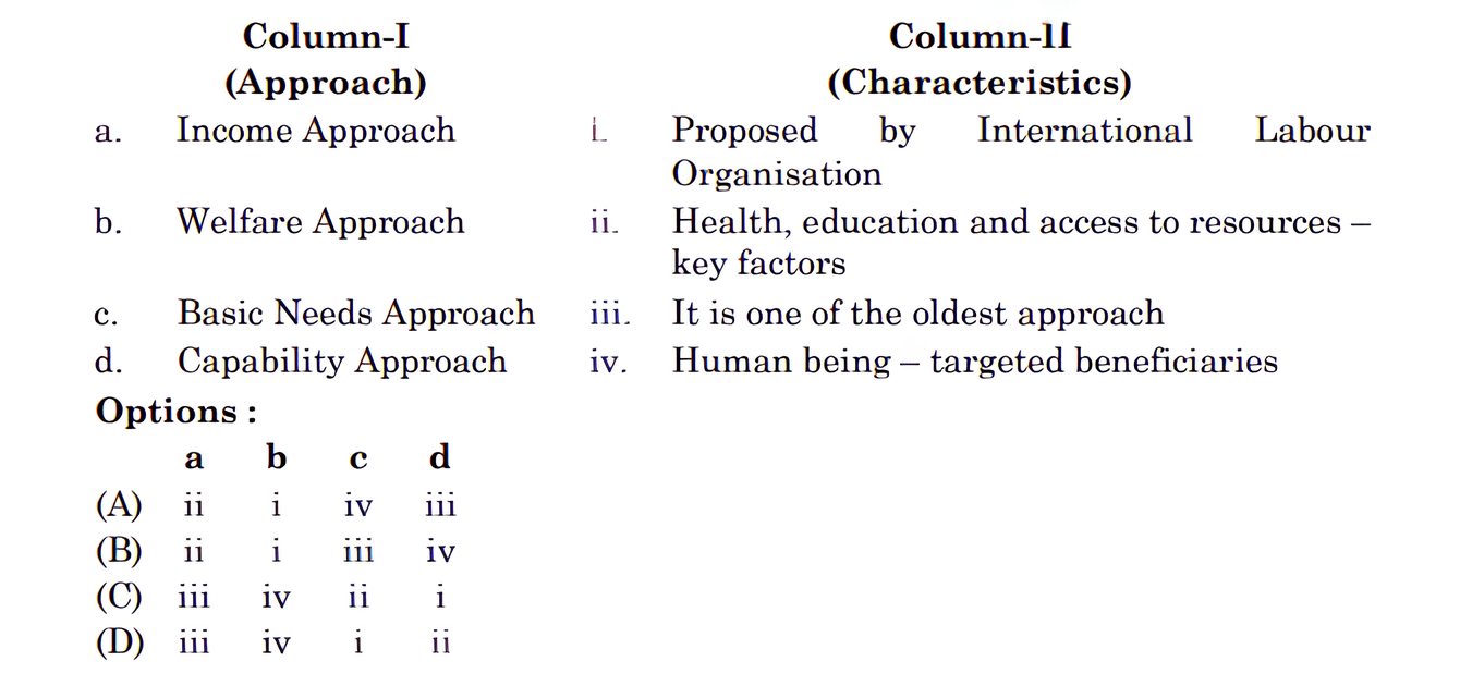
Income Approach (a-iii): This is one of the oldest approaches to human development, where development is linked to income levels.
Welfare Approach (b -iv): This approach views human beings as beneficiaries or targets of all developmental activities.
Basic Needs Approach (c- i): This was proposed by the International Labour Organisation (ILO) and emphasizes six basic needs.
Capability Approach (d -ii): Associated with Prof. Amartya Sen, focusing on building human capabilities in health, education, and resource access.
Which one of the following is the low latitudes zone of subsistence gathering practiced in the world ?
Choose the correct option related to oil tanker ports of the world.
Two statements are given below. They are Assertion (A) and Reason (R). Read both the statements carefully and choose the correct option :
Assertion (A) : All the developed countries have opened their markets for products from developing countries.
Reason (R) : World Trade Organisation deals with the global rules of trade between nations.
The Assertion (A) is false because not all developed countries have fully opened their markets for products from developing countries; there are still trade barriers and unequal conditions that often disadvantage developing nations, as noted in the context explaining how free trade can adversely affect developing countries by not giving an equal playing field. The Reason (R) is true because the World Trade Organisation (WTO) does deal with the global rules of trade between nations, helping regulate international trade and trade liberalisation.
Read the following statements carefully regarding ‘tertiary activities’ and choose the correct option :
I. Tertiary activities include both production and exchange of services.
II. Tertiary activities involve the commercial output of services.
III. Tertiary activities are directly involved in the processing of raw material.
IV. The examples of tertiary activities are – plumber, doctor, publisher. Options :
Choose the correctly matched pair from the following.
Choose the right group of states where Dravadian language is spoken majorly.
Which one of the following set of cities falling on the ‘Golden Quadrilateral’ are arranged in a clock-wise direction from Delhi ?
Which one of the following is a natural process of land degradation ?
The loudness of the sound is measured in the unit known as :
How many of the listed countries fall under Asian continent ?
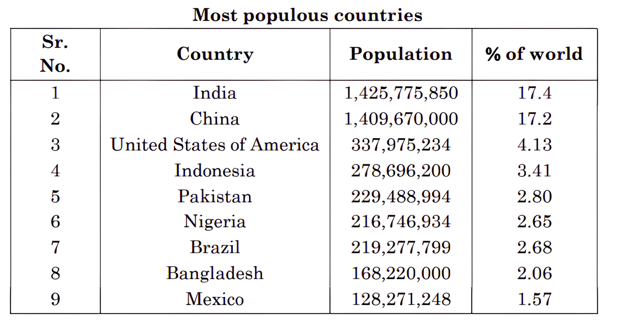
From the provided list of most populous countries, the 5 that are located in Asia are:
India
China
Indonesia
Pakistan
Bangladesh
Which of the following set of continents is not represented in the table ? Choose the most appropriate option.
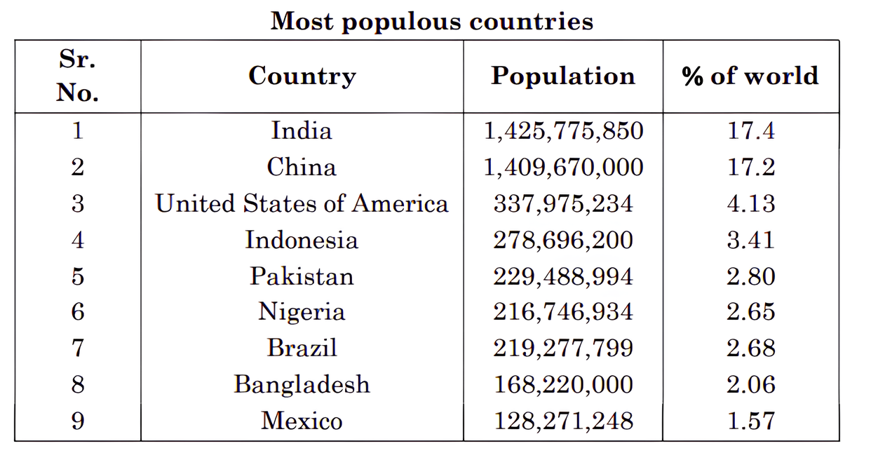
The table lists tectonic plates associated with several continents: Antarctica, North America, South America, Pacific region, India-Australia-New Zealand plate, Africa, and Eurasia (Europe and Asia) plate. Australia is included through the India-Australia-New Zealand plate, and Europe is part of the Eurasia plate. However, there is no set in the options that excludes both Australia and Europe simultaneously from the plates. Considering combinations, Australia and Europe as a pair are not represented together as separate continents in the table, unlike the other options which do show representation of their continents on different plates. Therefore, the set "Australia and Europe" is the correct answer for continents not represented together in the table.
China and Brazil together account for what percentage of the world population ?
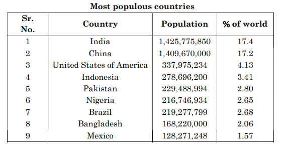
China = 17.2%
Brazil = 2.68%
Total = 17.20% + 2.68% = 19.88%
Section C
Examine the relationships between the ‘unresting man’ and ‘unstable earth’.
Examine the importance of ‘sustainability’ as a pillar of ‘human development’.
Sustainability is crucial for human development as it ensures that the opportunities and resources available today continue to be available for future generations. It means using environmental, financial, and human resources wisely without depleting them. This helps maintain ecological balance and prevents resource exhaustion. Sustainable human development focuses on long-term social and economic progress while conserving nature for the future, thus securing well-being for both present and coming generations. Without sustainability, the progress made would be short-lived and could harm the planet and society.
Therefore, sustainability acts as a backbone of human development by promoting responsible use of resources, preserving the environment and ensuring that all generations have equal chances to improve their lives. It also emphasizes understanding the physical environment to avoid ecological imbalance caused by rapid resource use. This concept emerged from global awareness about environmental issues, highlighting the need to combine economic growth with care for nature and social equity.
Explain the main characteristics of urban settlements in India.
1. Compact and Large Size: Urban settlements are generally compact and larger in size compared to rural settlements.
2. Non-Agricultural Activities: Most people in urban areas are engaged in non-agricultural activities such as trade, business, industries, and services.
3. Functional Linkage: Urban settlements are functionally linked to surrounding rural areas through the exchange of goods and services.
4. Variety of Functions: They serve various economic, administrative, educational, and cultural functions.
5. Dense Population: Urban areas have higher population density and diverse communities.
6. Modern Infrastructure: Urban settlements have better infrastructure like roads, electricity, water supply, schools, and hospitals.
7. Social and Cultural Diversity: Urban centers attract people from different regions, leading to a mix of cultures and lifestyles.
Explain the evolution of towns in India.
Towns in India have evolved over a long period starting from prehistoric times. During the Indus Valley Civilisation, towns like Harappa and Mohanjodaro were well established. After this period, towns continued to evolve through ups and downs until the arrival of Europeans in the eighteenth century.
Ancient Towns: Many ancient towns developed as religious and cultural centres. Examples include Varanasi, Prayag (Allahabad), Pataliputra (Patna), and Madurai. These towns have a history spanning over 2000 years.
Medieval Towns: Towns continued to grow during the medieval period with different influences but details are not specified.
Modern Towns: The British and other Europeans developed many coastal trading ports such as Surat, Daman, Goa, and Pondicherry. Later, they built major cities Mumbai (Bombay), Chennai (Madras), and Kolkata (Calcutta) in British architectural styles. Industrial towns like Jamshedpur emerged after 1850. Post independence, many administrative centers like Chandigarh, Bhubaneswar, Gandhinagar, and Dispur were developed along with industrial towns like Durgapur, Bhilai, Sindri, and Barauni. Some old towns also became satellite towns around big cities.
Thus, Indian towns evolved from ancient religious centres to modern industrial and administrative hubs over centuries.
Study the following table carefully and answer the questions that follow :
Why is the large difference between primary and tertiary categories of female workers ?
Explain the reason of low variation between male workers of ‘primary’ and ‘tertiary’ sectors.
Why ‘secondary sector’ has low contribution in India's workforce?
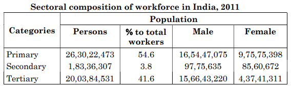
(b) The low variation between male workers in primary and tertiary sectors is due to men having broader access to different types of jobs, education, and mobility. Many men work both in agriculture (primary sector) and move to service or other tertiary sector jobs, resulting in a more balanced distribution.
(c) The secondary sector has low contribution in India’s workforce because industrial and manufacturing development is still growing and not enough to absorb a large workforce. Many workers continue to depend on agriculture or move to the tertiary sector for jobs. Also, lack of infrastructure, investment, and skill mismatch may limit growth of secondary sector employment.
Section D
“Industries should be located at points where the production costs are minimum.” Examine the statement with suitable arguments.
Industries aim to maximize profits by minimizing their production costs. Therefore, it is important to locate industries where these costs are lowest. Several factors influence the location of industries:
1. Access to Market: Industries are often located near their target markets to reduce transportation costs and ensure quick delivery of products.
2. Availability of Raw Materials: Industries like steel, sugar, and cement are located near the sources of bulky or perishable raw materials to save on transportation and maintain raw material quality.
3. Labour Supply: Availability of skilled or unskilled labour influences industrial location. Some industries need skilled workers while others may depend on abundant unskilled labour.
4. Access to Energy: Industries require a constant and reliable energy supply which affects their location.
5. Transport and Communication: Good transport and communication facilities help in smooth movement of raw materials and finished goods, as well as in managing business operations efficiently.
6. Govt. Policy: Governments promote balanced economic development by setting up industries in specific areas through regional policies.
7. Agglomeration Economies: Proximity to other industries and leader industries reduces costs by sharing resources and infrastructure.
In conclusion, industries should be located at points where the production costs including raw material procurement, labour, energy, transportation and infrastructure costs are minimum to maximize profit and efficiency.
“Railway is the mode of land transport for bulky goods and passengers over long distances.” In the context of this statement, explain the significance of railways in the world.
Railways are one of the most important modes of land transport, especially suited for carrying bulky goods and large numbers of passengers over long distances. They provide an economical and efficient means of transport because trains can carry a large volume of cargo or passengers at the same time, reducing transportation costs compared to road or air transport.
Railways operate on fixed tracks, making them reliable for scheduled transport and less affected by traffic congestion. They are also energy-efficient, reducing pollution per ton of freight or per passenger kilometer compared to roadways.
Internationally, railways connect major industrial and commercial centers, facilitating trade and economic growth within and across countries. For example, countries like Russia use railways extensively, with about 90% of transport occurring by train due to the vast distances involved.
Moreover, railways complement other transport modes by linking ports, airports, and road networks, enabling a smooth multimodal transport system. They are particularly useful for transporting heavy, bulky items such as coal, grains, minerals, and machinery that are not suitable for air transport.
In summary, railways play a crucial role in moving large quantities of goods and passengers cost-effectively over long distances, reducing road congestion and energy consumption, and supporting economic development worldwide.
“Road transport is the most economical for short distances compared to railway.” In the context of this statement, explain the significance of road transport in the world.
Road transport is the most economical mode for short distances because it provides flexibility and door-to-door services that railways cannot offer. It is widely used for carrying about 85 percent of passengers and 70 percent of freight every year globally.
Roads are essential for connecting rural and urban areas and supporting local economies, especially in developing countries where railway networks may not be extensive. They allow transportation of goods over short distances quickly and at a lower cost.
Although metalled roads can be used throughout the year, unmetalled roads often become unmotorable during the rainy season, limiting their effectiveness. Yet, roads are still vital for trade, commerce, and tourism by facilitating movement within the country.
Road transport also complements other modes like railways, airways, and ocean freighters. Railways handle large volumes of bulky goods over long distances, airways transport high-value and perishable items, and ocean freighters move international goods.
In summary, road transport plays an indispensable role in daily life by enabling short distance travel, providing door-to-door service, supporting economic growth, and integrating with other transport systems efficiently.
“Generally land-use in a region is influenced by the nature of economic activities.” Support the statement with suitable examples.
Land use in any region is closely related to the economic activities carried out there. The type of economic activity largely determines how the land in that area is used.
1. Agricultural Activities: In regions where agriculture is the main economic activity, most of the land is used for farming, growing crops, and raising livestock. For example, fertile plains in Punjab and Uttar Pradesh have vast agricultural land because the economy depends heavily on farming.
2. Industrial Activities: Areas with many industries have a large part of their land dedicated to factories, warehouses, and infrastructure needed for production. For instance, the areas around Mumbai and Gurgaon have more land used for industrial and commercial purposes due to the presence of industries and business hubs.
3. Urbanization and Services: In cities, land is used for housing, offices, schools, hospitals, and recreational purposes. Economic activities such as trade, education, and services require land for settlements and infrastructure. For example, metropolitan cities like Delhi and Bangalore have more land under urban use because of the dominance of tertiary economic activities.
4. Changes over time: Economic growth and population increase cause the expansion of non-agricultural land uses, reducing agricultural land. Urban sprawl leads to conversion of farmland into housing and industries. This can be seen near big cities where agricultural land is converted into colonies and industrial estates.
In summary, the nature of economic activities—whether primary like farming, secondary like industries, or tertiary like services—directly influences land use patterns in a region. This relationship explains why land use varies between rural and urban areas as the economy grows and changes.
“The Indian agricultural problems have physical constraints and institutional hindrances.” Support the statement with suitable examples.
Physical Constraints: These are natural or environmental factors that limit agricultural productivity. For example, small and fragmented land holdings reduce the efficiency of farming operations. Soil degradation and low fertility affect crop yields negatively. Irregular monsoon and dependence on rain-fed agriculture cause uncertainty in production. Lack of proper irrigation facilities in many regions further hampers consistent farming.
Institutional Hindrances: These are problems related to the structure and functioning of agricultural institutions. For instance, limited access to credit and high interest rates force many farmers to take loans from informal sources leading to indebtedness. Inefficient distribution of agricultural inputs and subsidies affects productivity. Inadequate storage facilities and poor market access lead to post-harvest losses and low income for farmers. Also, insufficient extension services prevent farmers from adopting modern techniques.
Conclusion: Thus, Indian agriculture is plagued by both physical hurdles like land fragmentation and climate variability and institutional problems such as lack of credit and poor market infrastructure. Addressing both these issues is essential for improving agricultural output and farmer welfare.
Explain the significance of petroleum as major source of energy and describe its distribution in India.
Petroleum is a very important source of energy because it provides fuel for many internal combustion engines used in automobiles, railways and aircraft. It is also processed to produce various by-products used in petrochemical industries such as fertilizers, synthetic rubber and synthetic fibres. With the growth of gas infrastructure, natural gas from petroleum is becoming increasingly important as a cleaner fuel for transport (CNG) and cooking (PNG) in homes. Petroleum fuels the development of transport, industry, agriculture, and other sectors, making it vital for the economy.
Distribution of Petroleum in India:
In India, petroleum reserves are mainly found in sedimentary basins. Major oil fields are located in Assam, which is the oldest oil-producing region, Gujarat, and the Mumbai High field which is an off-shore oil field in the Arabian Sea. Recently, new discoveries of petroleum reserves have been made in places like Tamil Nadu (Kanniyakumari), Kerala (Alleppey), Maharashtra (Ratnagiri), and West Bengal (Purulia and Bankura). These regions contribute significantly to India’s petroleum production. India is also expanding natural gas pipeline networks under the 'One Nation One Grid' initiative by GAIL, improving the distribution and availability of natural gas across the country.
Explain the significance of iron-ore as industrial raw material and describe its distribution in India.
Iron ore is a crucial raw material for the production of iron and steel, which are the backbone of heavy industries and infrastructure development. It is essential for manufacturing machinery, automobiles, construction materials, and tools. India has abundant iron ore reserves which help support its large steel industry, contributing significantly to the country’s economy and industrial growth. The availability of iron ore near coal fields lowers transportation costs and encourages the establishment of integrated steel plants.
Distribution of Iron Ore in India:
India is rich in iron ore reserves, having the largest deposits in Asia. The two main types of iron ore found are haematite and magnetite. About 95% of India’s iron ore reserves are concentrated in the states of Odisha, Jharkhand, Chhattisgarh, Karnataka, Goa, Telangana, Andhra Pradesh, and Tamil Nadu.
In Odisha, iron ore is found in hill ranges of Sundergarh, Mayurbhanj, and Jharsuguda districts. Jharkhand and Chhattisgarh are also important mining areas in the eastern plateau region, rich in iron ore and other minerals such as coal and manganese. The South-Western Plateau region, including Karnataka, Goa, Tamil Nadu, and Kerala, is another major belt rich in iron ore and bauxite.
The close proximity of iron ore mines to coalfields in eastern India provides an advantage for the steel industry, making this region a major hub for iron and steel production in the country.
Analyse the importance of Indian seaports in the development of international trade.
India has a vast coastline of approximately 7,517 km with 12 major ports and over 200 minor or intermediate ports. These seaports act as gateways for international trade, handling about 95 per cent of India's foreign trade by volume and 70 per cent by value. Historically, Indian ports have been in use since ancient times and gained significant importance after the arrival of European traders and British colonisation.
Seaports provide a smooth and cheap mode of transportation owing to the water routes, facilitating the movement of goods. The development of ports with modern infrastructure has significantly boosted international trade by enabling the handling of large volumes of exports and imports efficiently. Major ports are regulated by the central government which ensures policies supporting trade growth.
Furthermore, ports like Mumbai, Chennai, Kolkata (Diamond Harbour), and others have vast areas of influence, connecting India with global markets. These ports have been crucial in integrating India into the world economy by importing raw materials and exporting finished goods.
In summary, Indian seaports play a crucial role in economic development by supporting international trade, enhancing connectivity, and providing infrastructural facilities that help India maintain and expand its trade relations globally.
Analyse the changing pattern of India’s international trade.
In 1950-51, the total external trade of India was worth Rs. 1,214 crore. By 2020-21, this value increased drastically to Rs. 77,19,796 crore, showing a tremendous growth in trade volume.
The nature of India’s imports and exports has changed over time. Although the total volume of imports and exports has increased, the value of imports has generally remained higher than exports. This trade imbalance highlights the need for India to boost exports.
India’s contribution to world trade is about one per cent, which is low compared to its economy’s size. However, India plays a significant role in the world economy.
In recent years, India has taken several measures to improve its trade performance, such as import liberalisation (making imports easier), reduction in import duties, delicensing (reducing government control on industries), and shifting patent laws from process patents to product patents.
India aims to double its share in international trade within the next five years through these initiatives.
Moreover, the direction of trade has also changed with India strengthening trade relations with major partners across different regions, indicating diversification in its trading partners.
Thus, India’s international trade pattern shows remarkable growth in volume, diversification in trade partners, and a change in import-export composition supported by policy reforms aimed at enhancing trade competitiveness globally.
Other Years — Geography