CLASS 9 . SOCIAL SCIENCE . UNDERSTANDING SOCIETY INDIA AND BEYOND PART I . SHAPING OF-THE-EARTH-S-SURFACE
Chapter 2 : Shaping of the Earth’s Surface
Ch 2
SOCIAL SCIENCE
CLASS 9
Shaping of the Earth’s Surface
The Earth’s surface is constantly changing due to powerful forces working both inside and outside the planet. Internal forces, such as earthquakes, volcanic eruptions, folding, and faulting create mountains, valleys, and ocean basins, while external forces like weathering, erosion, and deposition slowly wear them down and reshape them. Together, these natural processes give rise to the diverse landforms we see today, from the highest peaks to the deepest ocean floors. Human life, too, is deeply connected to these landforms, as it influences our climate, resources, settlements, and cultures. Understanding the shape of the Earth’s surface helps us appreciate nature’s power and prepare wisely for natural disasters, ensuring a safer and more sustainable relationship with our planet.
Plate Tectonics
Plate tectonics is a fundamental theory in earth science that explains the movement of the Earth’s crust. The outermost layer of the Earth, called the lithosphere, is broken into several large and small pieces known as tectonic plates. These plates move slowly over the semi-molten asthenosphere beneath them. The movement of tectonic plates is driven by convection currents in the mantle, caused by heat from the Earth’s core.
The Earth consists of three main layers: the crust, mantle, and core. The crust is the outermost layer where we live. Beneath the crust lies the mantle, a thick and hot layer, followed by the core, which is extremely hot and dense. The lithosphere includes the crust and the upper part of the mantle, and it is divided into tectonic plates.
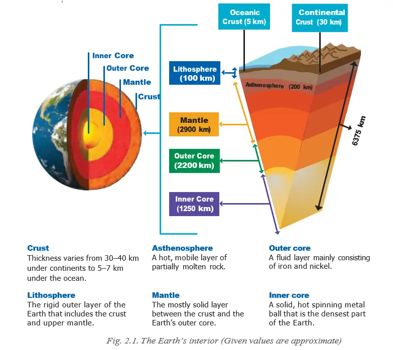
Tectonic plates are massive slabs of solid rock that move a few centimetres per year. There are three main types of plates: continental plates (carrying continents), oceanic plates (carrying ocean floors), and mixed plates (carrying both continents and oceans). Major plates include the Pacific Plate, Eurasian Plate, African Plate, North American Plate, South American Plate, Indo-Australian Plate, and Antarctic Plate.
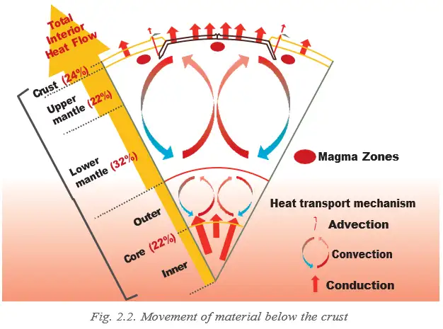
The movement of tectonic plates occurs due to convection currents in the mantle. Hot molten material rises while cooler material sinks, creating currents that push and pull the plates. Plate boundaries are the edges where plates meet, and there are three types:
- Convergent boundary: Plates move towards each other. Continental collisions form fold mountains like the Himalayas. Oceanic plates sinking beneath continental plates cause volcanic activity and earthquakes.
- Divergent boundary: Plates move away from each other. Magma rises to form new crust, creating mid-ocean ridges like the Mid-Atlantic Ridge.
- Transform boundary: Plates slide past each other without creating or destroying crust, causing earthquakes, e.g., San Andreas Fault.
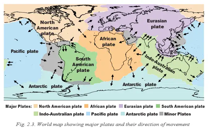
A world map shows major tectonic plates and their movement directions. The movement of these plates causes earthquakes, volcanoes, and mountain formation.
Exam Question
Q: What causes the movement of tectonic plates and what are the three types of plate boundaries?
A: The movement of tectonic plates is caused by convection currents in the mantle. The three types of plate boundaries are convergent (plates move towards each other), divergent (plates move away from each other), and transform (plates slide past each other).
Landforms
A landform is a natural feature on the Earth’s surface formed by processes such as weathering, erosion, deposition, and tectonic movements. Examples include mountains, valleys, plateaus, plains, deserts, and coastal features.
Weathering
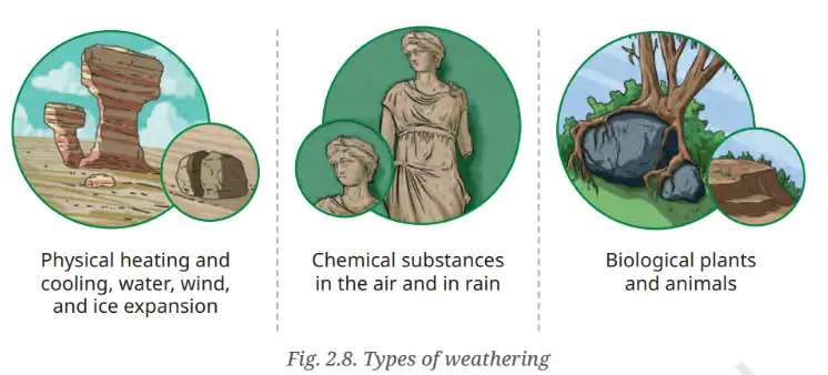
Weathering is the process of breaking down rocks into smaller pieces without movement. Types include physical weathering (due to temperature changes, frost, wind), chemical weathering (minerals change due to reactions with water, air, acids), and biological weathering (caused by plants, animals, microorganisms).
Exam Question
Q: What are the three types of weathering and how do they affect rocks?
A: The three types of weathering are physical (breaking rocks by temperature changes, frost, wind), chemical (changing minerals by reactions with water, air, acids), and biological (plants and animals breaking rocks). They break down rocks into smaller pieces and help form soil.
Erosion
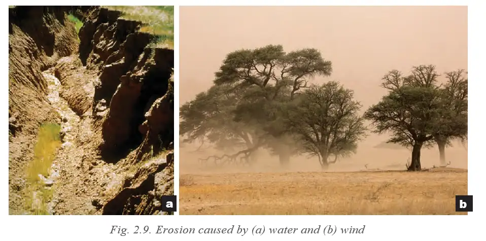
Erosion is the movement of soil, rocks, and surface materials by natural agents like water, wind, ice, or waves. Types include water erosion, wind erosion, glacial erosion, and coastal erosion. Erosion shapes landforms and affects human activities by removing fertile soil and damaging property.
Exam Question
Q: How does erosion affect human occupations?
A: Erosion removes fertile topsoil needed for farming, washes away land and property near rivers and coasts, destabilizes land for construction and mining, and affects tourism and fishing industries.
Agents of Gradation
Natural forces that wear down, transport, and deposit materials on the Earth’s surface are called agents of gradation. They include running water, glaciers, wind, waves, and underground water. These agents modify landforms by lowering high areas and filling low areas.
Running Water
Rivers shape landforms through erosion, transportation, and deposition. Upper course features include V-shaped valleys and waterfalls. Middle course features include meanders, oxbow lakes, and floodplains. Lower course features include deltas, levees, and alluvial fans.
Waterfall
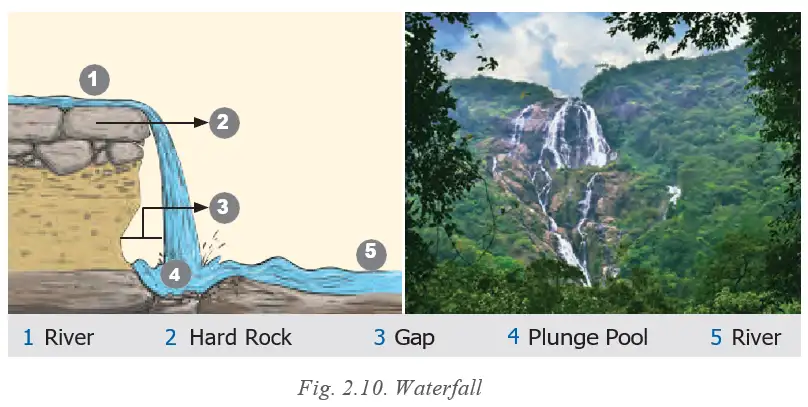
A waterfall is formed when a river flows over a steep cliff, creating a vertical drop. It forms where hard rock overlays softer rock that erodes faster. Waterfalls attract tourists and can be used for hydroelectric power.
Exam Question
Q: How is a waterfall formed and why is it important?
A: A waterfall forms when a river flows over hard rock with softer rock below that erodes faster, creating a vertical drop. It is important for tourism, hydroelectric power, and recreation.
Meander
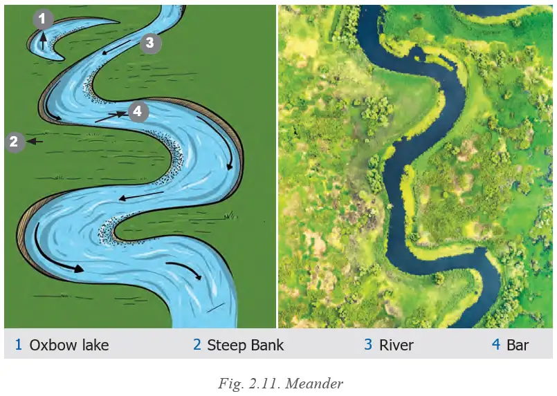
A meander is a winding curve in a river formed by erosion on outer banks and deposition on inner banks. Meanders support agriculture due to fertile soil and influence settlement patterns.
Exam Question
Q: What causes meanders and how do they benefit humans?
A: Meanders are caused by erosion on outer river banks and deposition on inner banks. They benefit humans by providing fertile soil for farming and influencing settlement locations.
Deltas
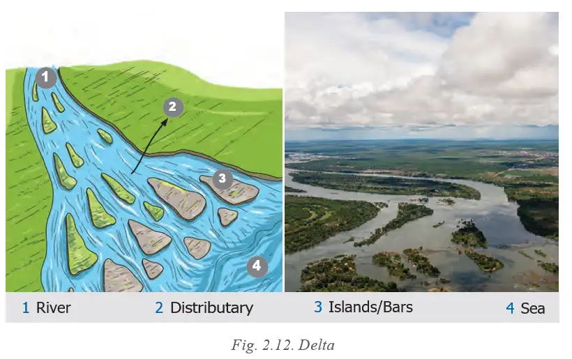
Deltas form at river mouths where sediment is deposited as the river meets the sea or lake. They are fertile, support agriculture and fishing, and are centers of trade and settlement but are prone to flooding.
Exam Question
Q: What is a delta and why is it important?
A: A delta is a landform at a river mouth formed by sediment deposits. It is important for fertile soil, agriculture, fishing, trade, and settlements.
Waves and Currents
Waves and currents reshape coastal landforms such as beaches, sand bars, cliffs, caves, arches, and stacks. Beaches are formed by sediment deposition and are important for tourism, fishing, and coastal protection.
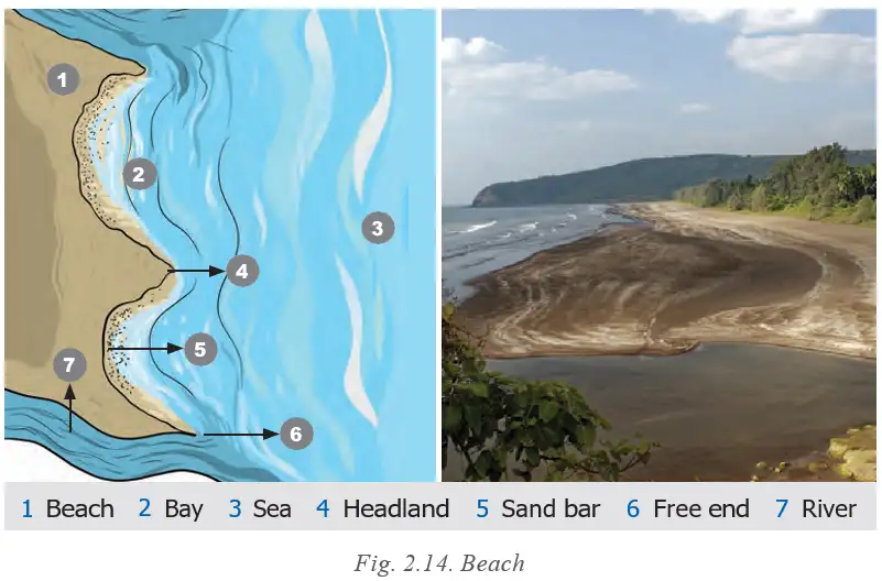
Coastal Erosion
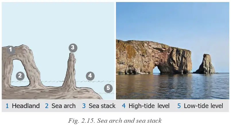
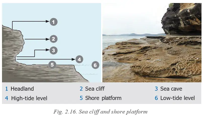
Coastal erosion by waves creates cliffs, wave-cut platforms, caves, arches, and stacks. These landforms influence tourism and require coastal protection measures.
Glaciers
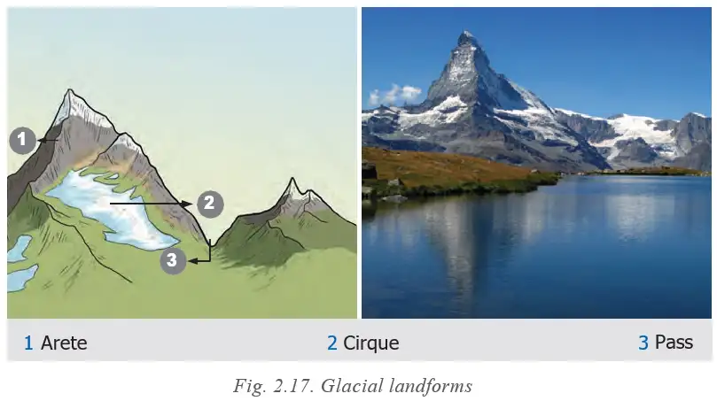
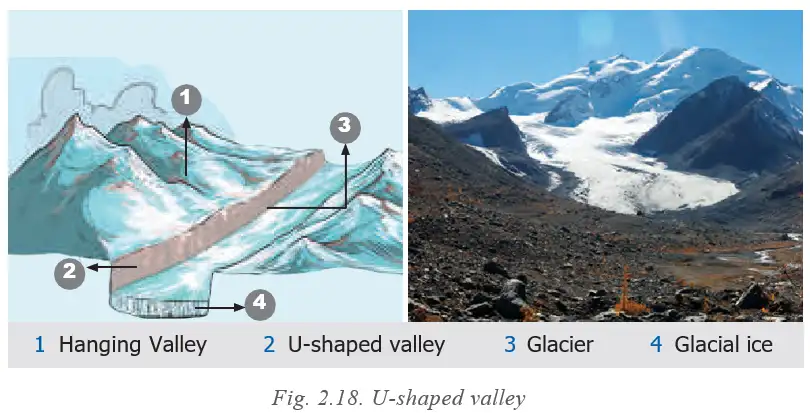
Glacial erosion shapes landforms such as U-shaped valleys, cirques, aretes, hanging valleys, and fjords. These landforms support tourism, agriculture, fishing, and provide fresh water.
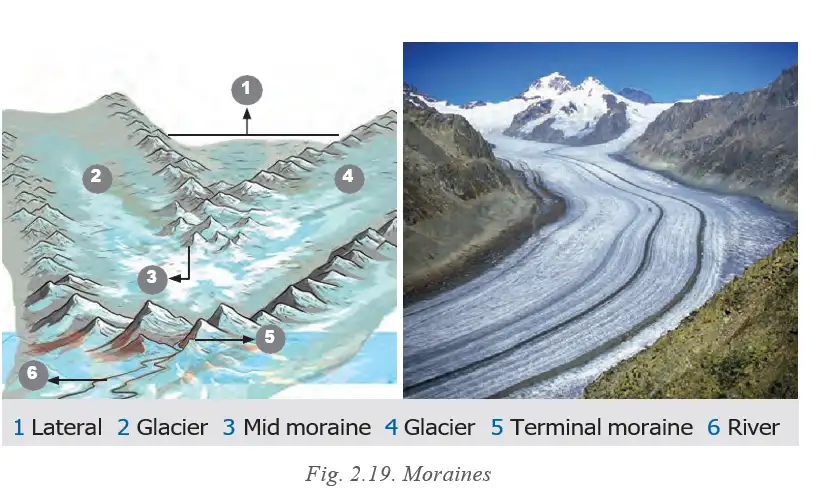
Moraines are landforms formed by deposition of debris by glaciers. Types include lateral, terminal, and medial moraines. They create fertile soil and natural dams used for water supply and hydroelectric power.
Exam Question
Q: What are moraines and how do they form?
A: Moraines are deposits of rocks and soil left behind by melting glaciers. They form lateral, terminal, and medial moraines depending on their location relative to the glacier.
Wind
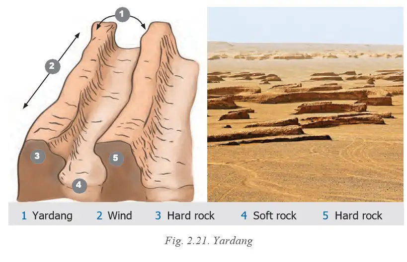
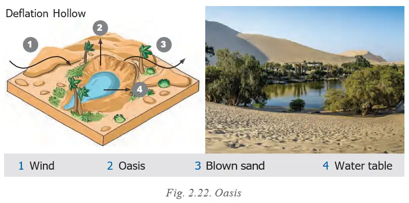
Wind erosion shapes landforms such as yardangs, ventifacts, deflation hollows, desert pavements, and dunes. Dunes act as natural barriers and support tourism and protection of settlements.
Exam Question
Q: How does wind shape landforms and what are dunes?
A: Wind erodes soft rock and carries sand and soil, forming landforms like yardangs and dunes. Dunes are hills of sand formed by wind, acting as barriers and supporting tourism and protection.
Underground Water
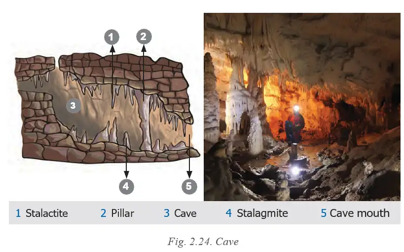
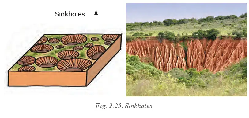
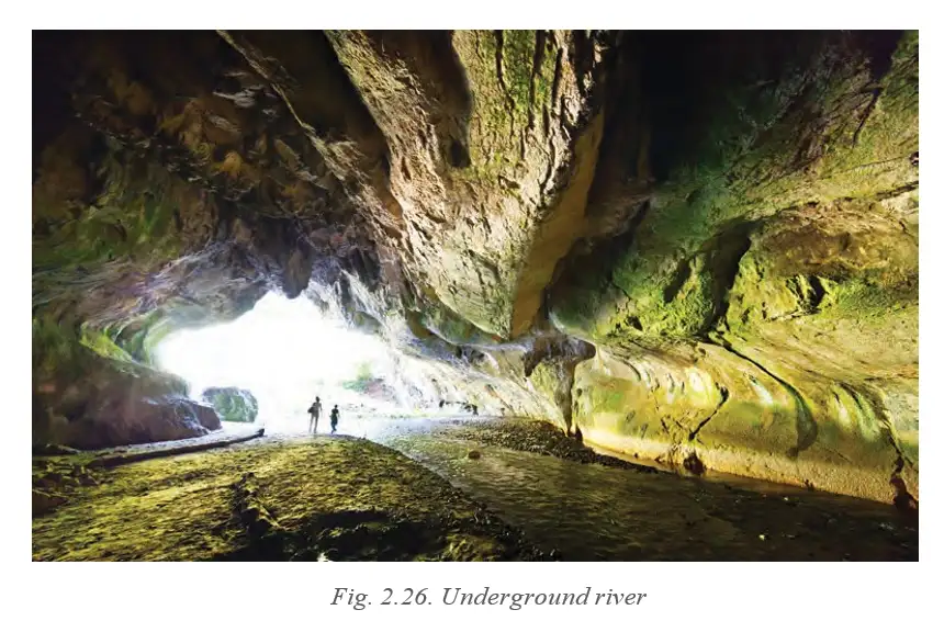
Underground water creates karst topography with landforms such as caves, stalactites, stalagmites, sinkholes, and underground rivers. These features provide water, tourism, and cultural significance.
Exam Question
Q: What landforms are created by underground water and why are they important?
A: Underground water creates caves, stalactites, stalagmites, sinkholes, and underground rivers. These landforms provide fresh water, tourism opportunities, and cultural significance.
Landforms and Disasters
Several disasters are associated with different landforms. Four major disasters are landslides, avalanches, glacial lake outburst floods (GLOFs), and dust storms. These disasters impact human lives and require mitigation measures.
Landslides
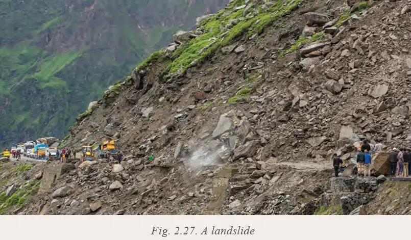
Landslides occur when slopes become unstable due to heavy rainfall, earthquakes, volcanic eruptions, steep slopes, loose rocks, deforestation, mining, and unplanned construction. They cause damage to roads, buildings, and can be life-threatening.
Exam Question
Q: What causes landslides and how can they be mitigated?
A: Landslides are caused by heavy rainfall, earthquakes, volcanic eruptions, steep slopes, and human activities like deforestation and construction. Mitigation includes proper land use, afforestation, drainage management, and avoiding construction on unstable slopes.
Avalanches
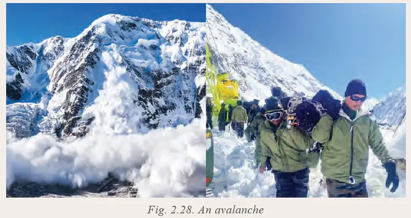
Avalanches are sudden slides of snow on steep mountain slopes caused by heavy snowfall, temperature changes, wind, earthquakes, and human disturbances. They pose risks to people and infrastructure in mountainous areas.
Exam Question
Q: What triggers avalanches and where do they occur?
A: Avalanches are triggered by heavy snowfall, temperature rise, wind, earthquakes, and human activities on steep mountain slopes. They occur in mountainous regions.
Glacial Lake Outburst Floods (GLOFs)
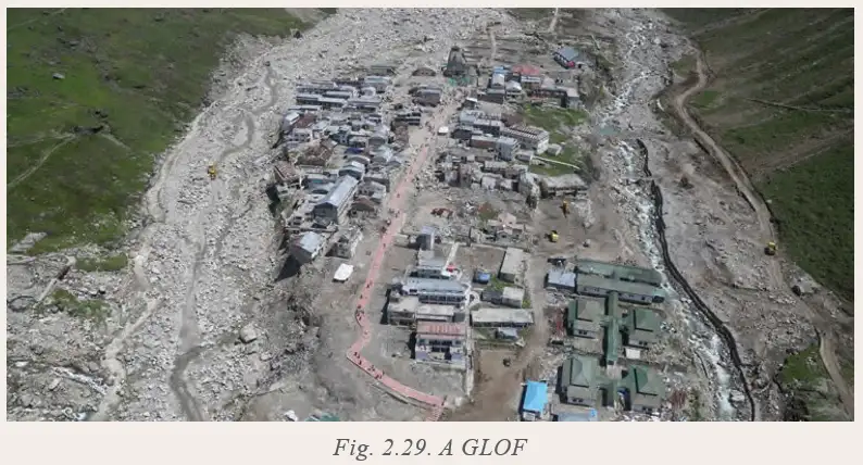
GLOFs happen when natural dams of glacial lakes break due to rapid melting, heavy rainfall, earthquakes, avalanches, or landslides, releasing large volumes of water suddenly and causing floods downstream.
Exam Question
Q: What causes Glacial Lake Outburst Floods and what are their effects?
A: GLOFs are caused by the sudden breaking of natural dams of glacial lakes due to melting, rainfall, earthquakes, or landslides. They cause destructive floods damaging buildings, roads, and natural areas downstream.
Dust Storms
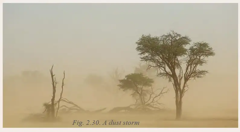
Dust storms occur when strong winds lift loose, dry soil and sand into the air, common in desert and semi-arid regions with drought, sparse vegetation, and poor land management. They reduce visibility, harm health, and damage crops and property.
Exam Question
Q: What causes dust storms and what are their impacts?
A: Dust storms are caused by strong winds lifting dry soil and sand, especially in drought-affected, sparsely vegetated areas. They reduce visibility, cause breathing problems, and damage crops and property.
Solved Examples
- Example: Explain the formation of fold mountains at convergent plate boundaries.
Answer: When two continental plates collide at a convergent boundary, the crust is pushed upwards forming fold mountains like the Himalayas. - Example: Describe the difference between weathering and erosion.
Answer: Weathering breaks down rocks in place without movement, while erosion involves the movement of broken materials by agents like water and wind.
Practice Set
Easy
- What are tectonic plates?
- Name three types of plate boundaries.
- Define weathering.
Moderate
- Explain how convection currents cause plate movement.
- Describe the formation of a delta.
- What are moraines and how do they form?
Challenging
- Discuss the impact of erosion on human activities.
- Explain the causes and effects of Glacial Lake Outburst Floods.
- Describe the formation and importance of meanders in rivers.
Answer Key
- Tectonic plates are large pieces of the Earth’s crust that move slowly over the mantle.
- The three types of plate boundaries are convergent, divergent, and transform.
- Weathering is the breaking down of rocks into smaller pieces without movement.
- Convection currents in the mantle cause the movement of tectonic plates by pushing and pulling them.
- A delta is formed at the mouth of a river by sediment deposition as it meets the sea or lake.
- Moraines are deposits of rocks and soil left behind by melting glaciers.
- Erosion removes fertile soil, damages property, and affects farming, construction, and tourism.
- Glacial Lake Outburst Floods are caused by the sudden breaking of natural dams of glacial lakes, leading to destructive floods downstream.
- Meanders form by erosion and deposition in rivers and provide fertile soil and support settlements.
Quick Reference
- Plate Tectonics: Theory explaining the movement of Earth’s crustal plates.
- Landforms: Natural features like mountains, valleys, plains, and deltas formed by geological processes.
- Weathering: Breaking down of rocks without movement.
- Erosion: Movement of soil and rock by natural agents.
- Agents of Gradation: Natural forces like water, wind, glaciers that shape landforms.
- Disasters: Natural events like landslides, avalanches, floods, and dust storms linked to landforms.
Glossary
- Convection Currents: Circular movement of molten material in the mantle causing plate movement.
- Fold Mountains: Mountains formed by the collision of tectonic plates.
- Meander: A winding curve in a river formed by erosion and deposition.
- Moraines: Deposits of debris left by glaciers.
- Plate Boundaries: Edges where tectonic plates meet.
- Weathering: The breaking down of rocks into smaller pieces.
- Erosion: The movement of soil and rock by natural forces.
- Delta: Landform at a river mouth formed by sediment deposits.
- Glacial Lake Outburst Floods (GLOFs): Sudden floods caused by the breaking of natural dams of glacial lakes.
- Yardang: A streamlined ridge formed by wind erosion.