CLASS 7 . SOCIAL SCIENCE . EXPLORING SOCIETY INDIA AND BEYOND PART I . GEOGRAPHICAL DIVERSITY-OF-INDIA
Chapter 1 : Geographical Diversity of India
Ch 1
SOCIAL SCIENCE
CLASS 7
Introduction to India’s Geographical Diversity
India, the seventh-largest country in the world, is renowned for its rich geographical diversity. Stretching from the snow-capped peaks of the Himalayas in the north to the tropical forests in the south, India's varied landscapes encompass mountains, plains, deserts, plateaus, coasts and islands. This diversity significantly influences the country’s climate, vegetation, culture and way of life.
Major Physical Features of India
- Himalayan mountains
- Northern plains
- Peninsular plateau
- Indian desert
- Coastal plains
- Island groups
Exam Question
Q: Name the major physical features of India.
A: The major physical features of India are the Himalayan mountains, Northern plains, Peninsular plateau, Indian desert, Coastal plains, and Island groups.
The Himalayas
The word ‘Himalaya’ is a combination of two Sanskrit words—hima, meaning ‘snow’, and alaya, meaning ‘abode’ or ‘dwelling’—thus, abode of snow. The Himalayan range is one of the largest mountain ranges in Asia that separates the Indo-Gangetic Plain from the Tibetan Plateau. This majestic range is home to some of the world’s highest peaks, including Mount Everest—the tallest mountain of our planet Earth at 8,848.86 metres (29,031.7 feet) above sea level.
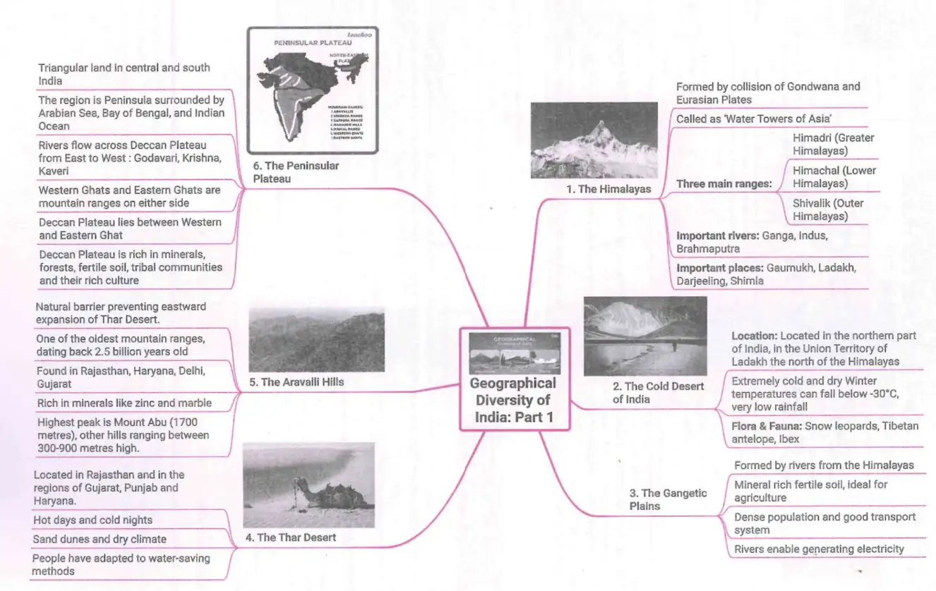
This image shows a mind map of the geographical diversity of India, highlighting six major features: The Himalayas, The Cold Desert, The Gangetic Plains, The Thar Desert, The Aravalli Hills, and The Peninsular Plateau.
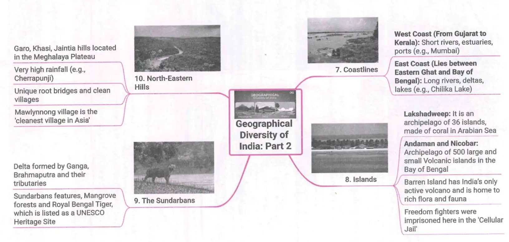
This image explains the geographical diversity focusing on North-Eastern Hills, Sundarbans, Coastlines, and Islands.
Geographical Extent of the Himalayas
The Himalayan range runs approximately 2,400 kilometres (1,500 miles) and spans five major Asian countries:
- India
- Nepal
- China (Tibet Autonomous Region)
- Bhutan
- Pakistan
The Himalayas are bordered by the Indo-Gangetic Plain to the south and the Tibetan Plateau to the north. To the northwest, it meets the Karakoram and Hindu Kush ranges. Several major rivers, including the Indus, Ganges and Brahmaputra, originate in the Himalayas, supporting the livelihoods of millions of species.
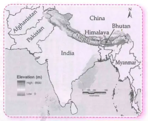
This map shows the Himalayan mountain range and its location relative to surrounding countries.
Formation of the Himalayas
The original Himalayas were totally different from what we see today. There was a large sea called the Tethys Sea between two landmasses.
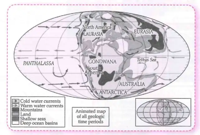
This map shows ancient supercontinents Laurasia and Gondwana and ocean currents.
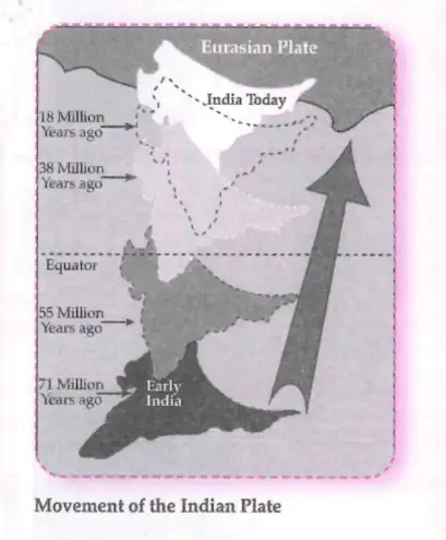
The Indian tectonic plate moved northward over millions of years, colliding with the Eurasian plate.
The Formation Process
- The Indian Plate (part of Gondwana Land) moved northward.
- It collided with the Eurasian Plate (part of Angara Land).
- The Tethys Sea bed folded and rose due to this collision.
- The folded land formed the Himalayan Mountain range.
This process continues today, causing the Himalayas to rise and experience earthquakes.
Exam Question
Q: How were the Himalayas formed?
A: The Himalayas were formed by the collision of the Indian Plate with the Eurasian Plate, which caused the Tethys Sea bed to fold and rise, creating the mountain range. This process is ongoing.
Division of the Himalayas
The snowmelt from the Himalayas feeds major rivers like the Ganga (Ganges), Indus and Brahmaputra, supporting millions of people.
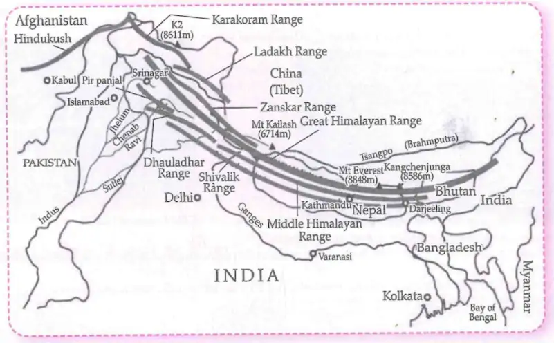
The Himalayas are divided into three main ranges:
1. Himadri (Greater Himalayas)
- Highest and northernmost range
- Contains Mount Everest and Kanchenjunga
- Covered with snow and glaciers
2. Himachal (Lesser Himalayas)
- Lies south of the Himadri
- Features popular hill stations like Shimla and Mussoorie
- Has moderate height and pleasant climate
3. Shivalik (Outer Himalayas)
- Southernmost and lowest range
- Composed of loose rocks and sediments
- Often has valleys between ranges (e.g., Dehradun)
Mnemonic to Remember the Divisions: “Go High Slowly” (G – Greater Himalayas, H – Himachal, S – Shivalik Hills)
Exam Question
Q: Name the three divisions of the Himalayas and one key feature of each.
A: The three divisions are Himadri (highest range with snow and glaciers), Himachal (moderate height with hill stations), and Shivalik (lowest range with loose rocks and valleys).
The Cold Desert of India
Ladakh, known as the Cold Desert, is a high-altitude region in northern India, between the Great Himalayas and the Karakoram Range. It features barren landscapes, deep valleys, and towering mountains.
Climate
- High altitude ranging from 3,000 to over 8,000 metres
- Summer daytime temperatures just above 0°C; night temperatures below −30°C
- Winters below −40°C
- Very low rainfall (about 10 cm annually) due to rain shadow effect
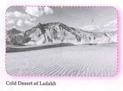
Flora and Fauna
- Sparse vegetation with grasses and shrubs
- Wild goats, sheep, yaks, and special dogs
- Birds like robins, redstarts, Tibetan snowcock, raven, and hoopoe
Human Adaptations
- Agriculture: barley, potatoes, peas, beans, turnips in summer
- Livestock: yaks for milk, meat, hides; sheep and goat wool
- Culture: Muslim and Buddhist populations; famous monasteries include Hemis, Thiksey, Shey, Lamayuru
Exam Question
Q: Describe the climate and human adaptations in the Cold Desert of Ladakh.
A: Ladakh has a cold, dry climate with low rainfall and extreme temperatures. People grow hardy crops in summer, rear yaks and sheep, and follow cultural traditions including Buddhism and Islam.
The Gangetic Plains
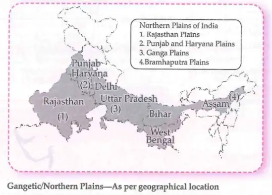
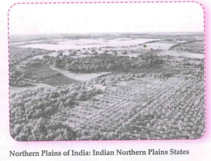
The Gangetic Plains, also called the Indo-Gangetic Plain, are vast flat areas in northern and eastern India formed by sediments from the Indus, Ganges and Brahmaputra rivers. They stretch from the Himalayas to the Deccan Plateau.
Fundamental Fact: Known as the “Granary of India” due to rich alluvial soil and high fertility.
Key Features
- Fertile soil
- Extensive irrigation
- High population density
Importance
- Agricultural hub growing rice, wheat, sugarcane
- Historical significance as home to ancient civilizations and cultural centers
Exam Question
Q: Why are the Gangetic Plains called the “Granary of India”?
A: Because of their fertile alluvial soil and extensive irrigation, the Gangetic Plains produce large quantities of food grains, making them the agricultural heartland of India.
The Great Indian Desert or Thar Desert
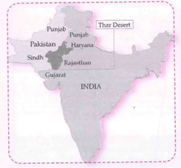
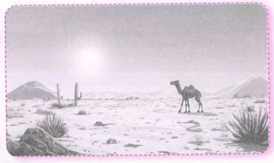
The Thar Desert, or Great Indian Desert, is located in north-western India, mainly in Rajasthan, extending into Pakistan. It is one of the largest deserts globally, known for extreme climate and unique features.
Location and Geography
- Between Aravalli hills and Rann of Kutch
- Area about 200,000 square kilometres
Climate and Weather
- Hot summers with temperatures above 50 °C
- Low rainfall (100–500 mm annually)
- Cold nights, especially in winter
Vegetation and Wildlife
- Sparse vegetation: cacti, thorny bushes, hardy grass
- Wildlife includes Indian Fox, Desert Lizard, Chinkara, Wild Camel, Blackbuck, Great Indian Bustard
People and Culture
- Adapted to desert life with rainwater harvesting and camel transport
- Rich cultural heritage with folk music, dance (Ghoomar), festivals (Teej, Gangaur)
- Camels called “ship of the desert”
Economic Activities
- Agriculture: millet, wheat
- Mining: salt, gypsum, minerals
- Tourism: camel rides, desert safaris, historic forts
Fundamental Fact: The Thar Desert hosts the Bhadla Solar Park, India’s largest solar power plant with 2,245 MW capacity.
Exam Question
Q: What are the main features of the Thar Desert and how do people adapt to its environment?
A: The Thar Desert has extreme temperatures, low rainfall, and sparse vegetation. People adapt by harvesting rainwater, using camels for transport, and practicing traditional agriculture and cultural activities.
The Aravalli Hills
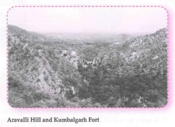
The Aravalli Hills are among the oldest mountain ranges in India, stretching across Delhi, Haryana, Rajasthan and Gujarat.
Key Features
- Age: About 2.5 billion years old
- Length: Approximately 670 km
- Highest Peak: Guru Shikhar (1,722 metres)
- Climate Role: Barrier preventing Thar Desert spread
- Mineral Wealth: Marble, granite, zinc, copper; ancient zinc mines at Zawar
- Historical Significance: Home to forts like Chittorgarh, Kumbhalgarh, Ranthambore
Exam Question
Q: What is the significance of the Aravalli Hills?
A: The Aravalli Hills are ancient mountains rich in minerals, act as a natural barrier to desert expansion, and contain historic forts important to India’s heritage.
The Peninsular Plateau
The Peninsular Plateau is a vast, ancient region of hard, rocky terrain forming the core of the Indian subcontinent.
Location
- South of the Indo-Gangetic Plain
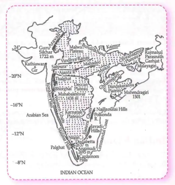
- Surrounded by Aravalli Hills, Vindhya and Satpura Ranges, Eastern and Western Ghats
Geographical Features
Divided into:
- Central Highlands (Aravalli, Vindhya, Chhotanagpur Plateau)
- Deccan Plateau (Maharashtra, Karnataka, Telangana, Andhra Pradesh, Tamil Nadu)
Major Rivers
Drained by rivers like Narmada, Tapi, Mahanadi, Godavari, Krishna, Kaveri flowing to Arabian Sea or Bay of Bengal.
Age and Composition
- One of the oldest landforms in India
- Made of hard crystalline rocks like granite and gneiss
- Deccan Plateau formed by volcanic lava flows, giving fertile black soil
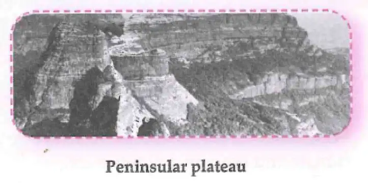
Fundamental Fact: The Deccan Plateau is called the “Land of Lava” due to volcanic origin of its soil.
Physiographic Features
- Rivers mostly east-flowing to Bay of Bengal; some west-flowing to Arabian Sea
- Eastern side slopes gently; western side steep with Western Ghats
- Elevation: Deccan Plateau 600-900 m; Central Highlands about 500 m
Major Ranges and Hills
- Aravalli Hills
- Vindhya and Satpura Ranges
- Western Ghats (Sahyadri Range)
- Eastern Ghats
Climate and Agriculture
- Hot summers with temperatures above 40 °C
- Fertile soils support crops like cotton, groundnut, sugarcane, rice, millet
- Rivers provide irrigation
Wildlife
Rich biodiversity with tiger reserves and sanctuaries like Sundarbans, Bandipur, Kaziranga.
Economic Importance
Rich in minerals such as coal, iron ore, manganese, bauxite; important for mining and industry.
Exam Question
Q: Describe the Peninsular Plateau and its significance.
A: The Peninsular Plateau is an ancient, rocky landform divided into Central Highlands and Deccan Plateau. It supports agriculture, rich mineral resources, and diverse wildlife, making it economically and ecologically important.
India’s Amazing Coastlines
India’s coastline stretches over 7,500 km and is divided into two main coastal plains: the Eastern Coastal Plains and the Western Coastal Plains.
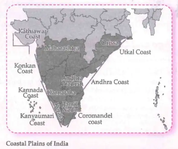
Western Coastal Plains (Gujarat to Kerala)
- Narrow strip between Western Ghats and Arabian Sea, about 1,500 km long
- Short, fast-flowing rivers forming estuaries
- Rocky coastlines, coves, creeks, lagoons
- Major ports: Mumbai, Kandla, Kochi
- Agriculture: rice, millet, coconuts

Eastern Coastal Plains (West Bengal to Tamil Nadu)
- Broader strip between Eastern Ghats and Bay of Bengal
- Long, slow-flowing rivers forming deltas (Mahanadi, Godavari, Krishna, Kaveri)
- Wide plains, fertile deltas, lakes like Chilika and Pulicat
- Major ports: Chennai, Paradip
- Climate influenced by northeast monsoon

Exam Question
Q: Compare the Western and Eastern Coastal Plains of India.
A: The Western Coastal Plains are narrow with short rivers and rocky coastlines, hosting major ports like Mumbai. The Eastern Coastal Plains are broader with long rivers forming fertile deltas and ports like Chennai.
Indian Islands
India has two major island groups:
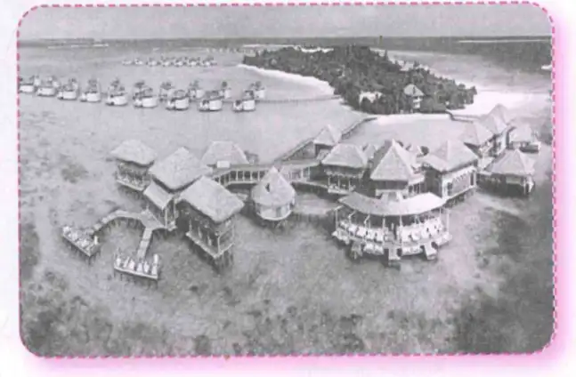
- Lakshadweep Islands: Located in the Arabian Sea, off the south-western coast of India.
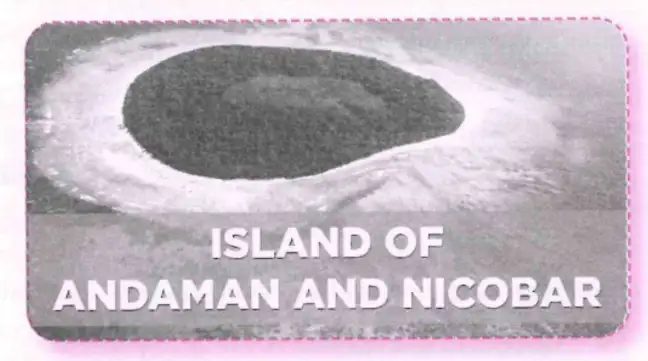
- Andaman and Nicobar Islands: Situated in the Bay of Bengal, south-east of the mainland.
Lakshadweep Islands
- About 200–400 km off Kerala coast
- 36 islands including 12 atolls, 3 reefs, 5 submerged banks
- Capital: Kavaratti
- Only 10 islands inhabited
- Economy: fishing, coconut cultivation, tourism
- Known for coral reefs and marine biodiversity
Interesting Fact: Majuli Island on the Brahmaputra River is the world’s largest river island, known for Assamese culture and wildlife.
Andaman and Nicobar Islands
- Located in the Bay of Bengal, between 6° and 14° North latitude
- Over 500 islands divided into Andaman and Nicobar groups
- Capital: Port Blair
- About 31 islands inhabited
- Economy: agriculture, fishing, tourism
- Home to unique flora and fauna like the Nicobar pigeon
Exam Question
Q: What are the main features and economic activities of the Lakshadweep and Andaman and Nicobar Islands?
A: Lakshadweep Islands are coral islands with fishing, coconut farming, and tourism as main activities. Andaman and Nicobar Islands are volcanic with agriculture, fishing, and tourism, and have rich biodiversity.
The Delta in West Bengal and the Sundarbans
How Deltas Are Formed
Deltas form where rivers meet the sea, depositing sediments that create fertile land and unique ecosystems.
Sundarbans Delta
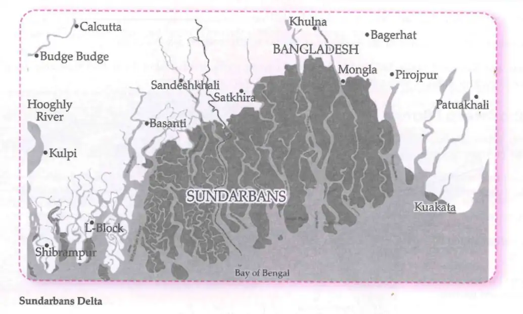
The Sundarbans, formed by the Ganga and Brahmaputra rivers, is one of the largest delta regions in the world. It features tidal waterways, mudflats, and mangrove forests that protect coastal areas from erosion and storms.
The Sundarbans are vital for ecological balance and support the economy of West Bengal.
Exam Question
Q: Why is the Sundarbans Delta important?
A: The Sundarbans protect coastal areas from storms, support diverse wildlife including the Royal Bengal Tiger, and provide resources for local livelihoods and tourism.
The Hills of the Northeast
The hills of Northeast India include parts of the Himalayas and the Purvanchal Hills, such as the Naga Hills, Mizo Hills, and Patkai Range. This region is known for rugged terrain, dense forests, heavy rainfall, and rich biodiversity. It feeds the Brahmaputra River and is home to many indigenous communities.
Solved Examples
Example 1
Q: Explain the significance of the Himalayan mountain range for India.
A: The Himalayas act as a natural barrier protecting India from cold Central Asian winds, influence the monsoon climate, are the source of major rivers like the Ganga and Brahmaputra, and support diverse ecosystems and cultures.
Example 2
Q: Describe the main features of the Thar Desert.
A: The Thar Desert is a hot, arid region with extreme temperatures, sparse vegetation like cacti, animals adapted to desert life such as camels, and a culture rich in folk traditions. It is important for agriculture, mining, and tourism.
Practice Set
Easy
- Name the three divisions of the Himalayas.
- What is the “Granary of India”?
Moderate
- Explain how the Himalayas were formed.
- List two economic activities in the Thar Desert.
Challenging
- Compare the Western and Eastern Coastal Plains of India in terms of geography and economic importance.
- Describe the significance of the Sundarbans delta for ecology and local communities.
Answer Key
- Himadri (Greater Himalayas), Himachal (Lesser Himalayas), Shivalik (Outer Himalayas)
- Gangetic Plains
- The Himalayas were formed by the collision of the Indian Plate with the Eurasian Plate, causing the Tethys Sea bed to fold and rise.
- Agriculture (millet, wheat) and mining (salt, gypsum, minerals)
- The Western Coastal Plains are narrow with short rivers and major ports like Mumbai; the Eastern Coastal Plains are broader with long rivers forming deltas and ports like Chennai.
- The Sundarbans protect coastal areas from storms, support diverse wildlife, and provide livelihoods through fishing, agriculture, and tourism.
Quick Reference
- Himalayas: Highest mountain range, source of major rivers.
- Gangetic Plains: Fertile alluvial plains, agricultural heartland.
- Thar Desert: Hot desert with unique flora, fauna, and culture.
- Aravalli Hills: Oldest mountain range, mineral rich.
- Peninsular Plateau: Ancient rocky landform, rich in minerals and agriculture.
- Coastlines: Western and Eastern coastal plains with distinct features and economic importance.
- Islands: Lakshadweep and Andaman & Nicobar, important for biodiversity and economy.
- Sundarbans: Largest delta with mangrove forests and ecological significance.
Glossary
- Abode: A place of residence or dwelling.
- Alluvial Soil: Fertile soil deposited by rivers.
- Atoll: A ring-shaped coral reef or island.
- Delta: Landform at the mouth of a river formed by sediment deposits.
- Estuary: The tidal mouth of a large river.
- Monsoon: Seasonal wind bringing heavy rainfall.
- Plateau: Elevated flat land.
- Rain Shadow: Dry area on the leeward side of a mountain.
- Tectonic Plates: Large slabs of Earth's crust that move and cause geological activity.
- Volcanic Lava: Molten rock erupted from a volcano.