CLASS 6 . SOCIAL SCIENCE . EXPLORING SOCIETY INDIA AND BEYOND . LOCATING PLACES-ON-THE-EARTH
Chapter 1 : LOCATING PLACES ON THE EARTH
Ch 1
SOCIAL SCIENCE
CLASS 6
Locating Places on the Earth
Introduction
The Earth is a spherical body composed of fire, water, land, and air, situated in space. It supports all living beings, both aquatic and terrestrial. When visiting a new city, we often refer to its map to understand the location of various places.
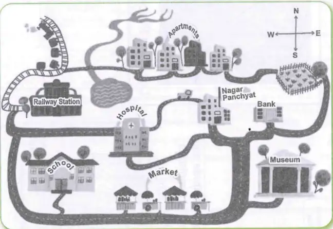
This map shows a town with places like a railway station, hospital, school, apartments, market, bank, museum, and Nagar Panchayat (local government office), connected by roads and a railway line. A compass indicates the cardinal directions: North, South, East, and West.
What is a Map?
A map is a plane representation of the Earth's surface or a part of it, drawn on a flat surface according to a scale. Different types of maps indicate various features. Many maps compiled together form an atlas.
A Map and its Components
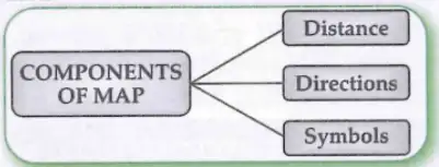
The three main components of a map are:
- Distance: Scale represents the ratio between actual ground distance and the distance shown on the map.
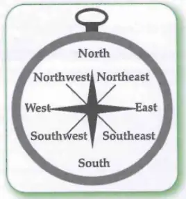
- Direction: Cardinal points—North, South, East, and West—help locate places. Intermediate directions include North-East, South-East, South-West, and North-West. A magnetic compass is used to find directions.
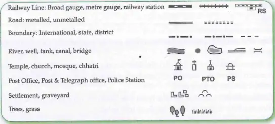
- Symbols: Conventional symbols represent features on the map. Blue indicates water bodies, brown for mountains, yellow for plateaus, and green for plains.
Kinds of Maps
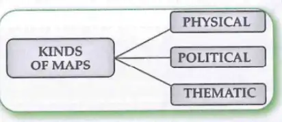
Maps provide more information than globes and are classified as:
- Physical Maps: Show natural features like mountains, plateaus, plains, rivers, and oceans.
- Political Maps: Show cities, towns, villages, countries, and states with boundaries.
- Thematic Maps: Focus on specific information such as roads, rainfall, forests, or industries.
Mapping the Earth
The globe is a spherical model of the Earth showing the North and South Poles. The Equator lies halfway between the poles. Latitude and longitude are the two coordinates used to locate places on Earth.
Important Parallels of Latitude:
- Tropic of Cancer (23½°N)
- Tropic of Capricorn (23½°S)
- Arctic Circle (66½°N)
- Antarctic Circle (66½°S)
Parallels of latitude and meridians of longitude form a grid on the globe, called grid lines.
Fundamental Fact: The 180°W and 180°E longitudes are the same and marked as 180° without W or E.
Understanding Time Zones
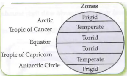
The Earth is divided into climate zones based on latitude:
- Torrid Zone: Receives maximum heat.
- Temperate Zone: Has moderate temperature.
- Frigid Zone: Has cold climate due to slanting sunrays.
The Earth rotates 360° in about 24 hours. Standard Time is when a watch reads 12 o'clock as the Sun is at its highest point in the sky at a place.
Local times vary, so countries adopt a central meridian's local time as Standard Time. India’s Standard Meridian is 82½°E, passing through Mirzapur, and Indian Standard Time (IST) is 5 hours 30 minutes ahead of Greenwich Mean Time (GMT).
Some countries with large longitudinal extent have multiple time zones. The Prime Meridian at Greenwich is 0° longitude, and the opposite line at about 180° longitude is the International Date Line.
Keywords
- Globe: A true miniature model of the Earth showing latitudes and longitudes.
- Atlas: A book of maps.
- Scale of a Map: Ratio of actual distance to map distance.
- Frigid Zones: Areas beyond Arctic and Antarctic Circles with cold climate due to slanting sunrays.
- Parallel of Latitudes: Circles parallel to the Equator, important for locating places.
- Tropic of Cancer: 23½°N latitude where the Sun is overhead on 21st June.
- Tropic of Capricorn: 23½°S latitude where the Sun is overhead on 22nd December.
- Arctic Circle: 66½°N latitude with 24 hours daylight on 21st June.
- Antarctic Circle: 66½°S latitude with 24 hours daylight on 22nd December.
- Local Time: Time of a place based on its longitude.
- Grid: Network of latitude and longitude lines on the globe.
- Plan: A large-scale drawing of a small area, showing details not possible on maps.
- Symbols: Pictures or icons representing features on maps.
- Longitudes: Lines running North-South, measured east or west from the Prime Meridian.
- Prime Meridian: 0° longitude passing through Greenwich.
- Standard Time: Uniform time adopted for a country based on a central meridian.
- Standard Meridian in India: 82½°E longitude passing through Mirzapur.
- Estuary: Place where a river meets the sea.
Solved Examples
Example 1: What are the main components of a map?
Answer: The main components of a map are distance (scale), direction (cardinal and intermediate points), and symbols representing features.
Example 2: Why is the Indian Standard Time (IST) 5 hours 30 minutes ahead of GMT?
Answer: Because India is located east of Greenwich at 82½°E longitude, the local time here is ahead of GMT by 5 hours 30 minutes, which is adopted as IST.
Practice Set
Easy
- Define a map.
- What are the four cardinal directions?
- What is a globe?
Moderate
- Explain the difference between physical and political maps.
- What is the significance of the Tropic of Cancer?
- Describe the components of a map.
Challenging
- How do latitude and longitude help in locating places on Earth?
- Explain the concept of time zones and why they are necessary.
- Describe the importance of the Prime Meridian and the International Date Line.
Answer Key
- Easy 1: A map is a plane representation of the Earth's surface or part of it drawn to scale.
- Easy 2: North, South, East, and West.
- Easy 3: A globe is a true miniature model of the Earth.
- Moderate 1: Physical maps show natural features; political maps show boundaries and cities.
- Moderate 2: Tropic of Cancer is the latitude where the Sun is overhead on 21st June.
- Moderate 3: Components are distance (scale), direction, and symbols.
- Challenging 1: Latitude and longitude form a grid to pinpoint exact locations on Earth.
- Challenging 2: Time zones standardize time across regions due to Earth's rotation and varying local times.
- Challenging 3: The Prime Meridian is 0° longitude; the International Date Line marks the change of calendar day.
Quick Reference
- Map: Flat representation of Earth's surface.
- Scale: Ratio of map distance to actual distance.
- Cardinal Directions: North, South, East, West.
- Latitude: Horizontal lines parallel to Equator.
- Longitude: Vertical lines from pole to pole.
- Standard Time: Uniform time for a region.
- Indian Standard Time: Time at 82½°E longitude.
Glossary
- Atlas
- A collection of maps.
- Compass
- Instrument showing directions.
- Equator
- Imaginary line dividing Earth into Northern and Southern Hemispheres.
- Intermediate Directions
- Directions between cardinal points: NE, SE, SW, NW.
- Meridian
- Line of longitude.
- Parallels
- Lines of latitude.
- Prime Meridian
- 0° longitude line passing through Greenwich.
- Scale
- Ratio of map distance to actual distance.
- Standard Meridian
- Central meridian used for standard time.
- Time Zone
- Region with uniform standard time.
| Time Period / Year | Event / Change | Importance |
|---|---|---|
| 0° Longitude (Greenwich) | Prime Meridian established | Reference for longitude and time |
| 82½°E Longitude (Mirzapur) | Indian Standard Meridian fixed | Standard time for India (IST) |
| 21 June | Sun overhead at Tropic of Cancer | Marks beginning of summer in Northern Hemisphere |
| 22 December | Sun overhead at Tropic of Capricorn | Marks beginning of winter in Northern Hemisphere |
| 180° Longitude | International Date Line | Marks change of calendar day |