CLASS 6 . SOCIAL SCIENCE . EXPLORING SOCIETY INDIA AND BEYOND . LANDFORMS AND-LIFE
Chapter 3 : LANDFORMS AND LIFE
Ch 3
SOCIAL SCIENCE
CLASS 6
Introduction
Humans, like most mammals, live on land.
A landform is a geographic feature found on Earth’s surface. With millions of years to form, landforms play a crucial role in environment and life. They fall into three general categories: plains, mountains and plateaus.
These landforms support a diverse range of flora and wildlife and have varying climates. All landforms have been adapted to by humans, yet different landforms have varied populations worldwide.
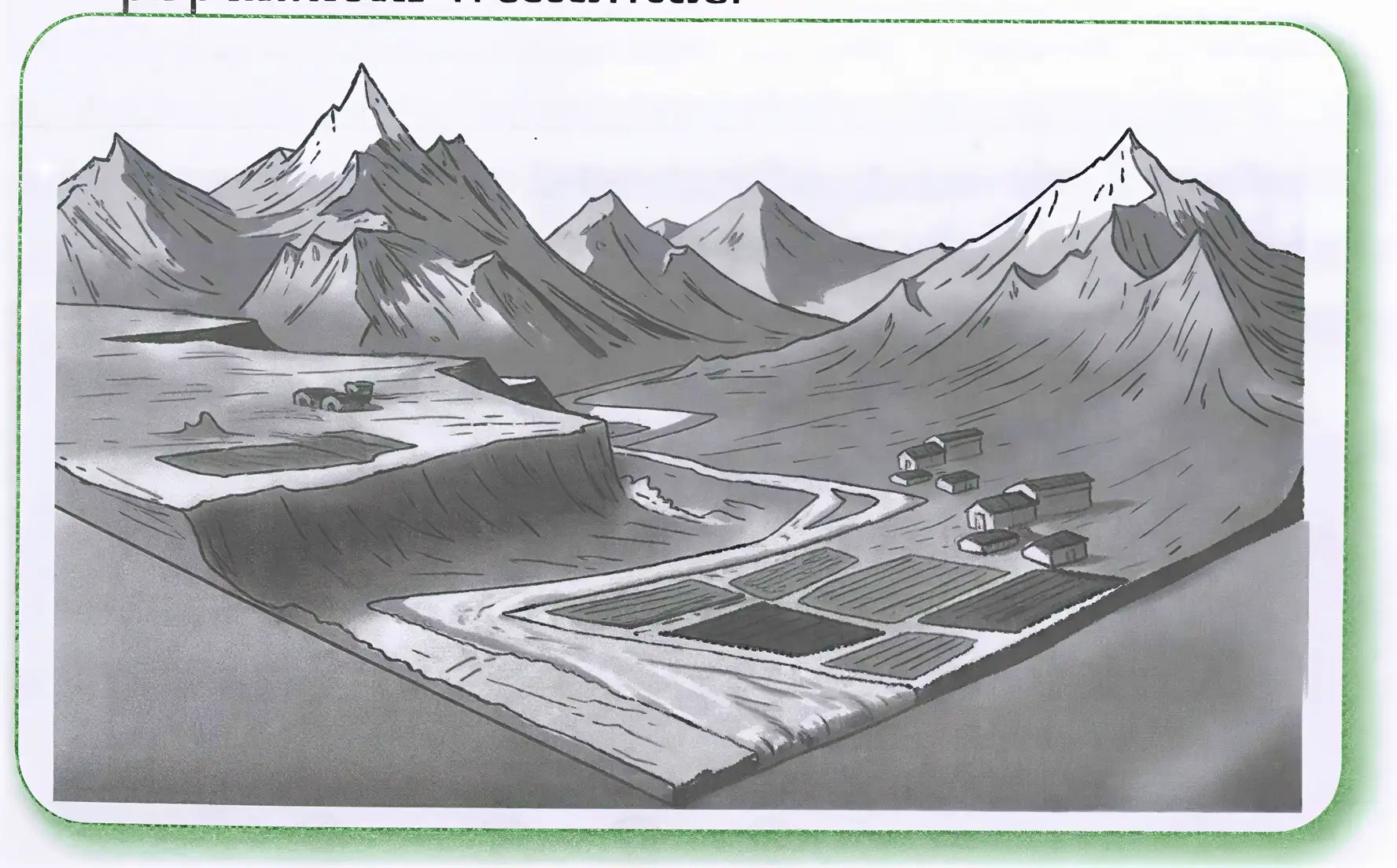
The image shows a glacial valley with a glacier flowing down from the mountains, carving out the land. There are fields and buildings near the valley, indicating human activity.
Step-by-step explanation for high school students:
- A glacier forms when snow accumulates and compresses into ice over many years in the mountains.
- This glacier slowly moves downhill due to gravity.
- As the glacier moves, it scrapes and erodes the land beneath it, creating a deep U-shaped valley.
- The glacier carries rocks and debris, which shape the valley sides and floor.
- When the glacier melts, it leaves behind fertile soil in the valley.
- People use this land for farming and building homes, as shown by the fields and buildings near the valley in the image.
Mountains
Identifying features
A broad base, steep slopes and a narrow summit are characteristics of mountains. Depending on their height, some mountains may be covered in snow; at lower elevations, the snow melts every summer and feeds rivers; at higher elevations, the snow may never melt, leaving the mountain perpetually snow-capped. Hills are other highlands that are lower in elevation, have less steep slopes and have rounded tops. The majority of the world’s mountains are arranged in mountain ranges, such the Andes in South America, the Alps in Europe, and the Himalayas in Asia. A few of these ranges are thousands of kilometres long.
Exam Question
Q: What are the main characteristics of mountains and how do they differ from hills?
A: Mountains have a broad base, steep slopes, and a narrow summit. They can be snow-capped depending on height. Hills are lower in elevation, have less steep slopes, and rounded tops.
Mountain environment
A type of forest known as montane forest, which is home to conifer species like pines, firs, spruces and deodar, is frequently seen covering mountain slopes. These tall, cone-shaped conifer trees have thin, pointed leaves. Higher up, lichen, mosses and grasses replace the trees.
The two tallest peaks in the Himalayan range are Mount Everest, which is situated between Tibet (China) and Nepal, and Kanchenjunga, which is situated between Nepal and the Indian state of Sikkim. The tallest peak in the Andes is Mount Aconcagua, which is located in South America. Located in eastern Africa, Mount Kilimanjaro is a solitary peak that is not a part of any range. The tallest peak in the Alps is Mont Blanc, located in Western Europe. South India’s highest mountain is Anamudi, sometimes called “Anai Peak” because it is located in Kerala.
Exam Question
Q: Name some of the tallest mountains in the world and their locations.
A: Mount Everest (between Tibet and Nepal), Kanchenjunga (between Nepal and Sikkim), Mount Aconcagua (South America), Mount Kilimanjaro (eastern Africa), Mont Blanc (Western Europe), and Anamudi (South India).
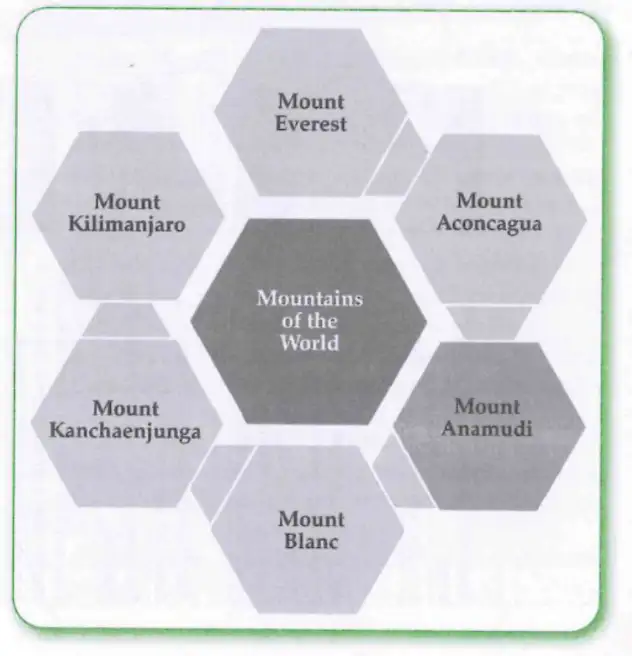
This image shows a graphic organizer listing famous mountains around the world: Mount Everest, Mount Kilimanjaro, Mount Kanchenjunga, Mont Blanc, Mount Anamudi, and Mount Aconcagua.
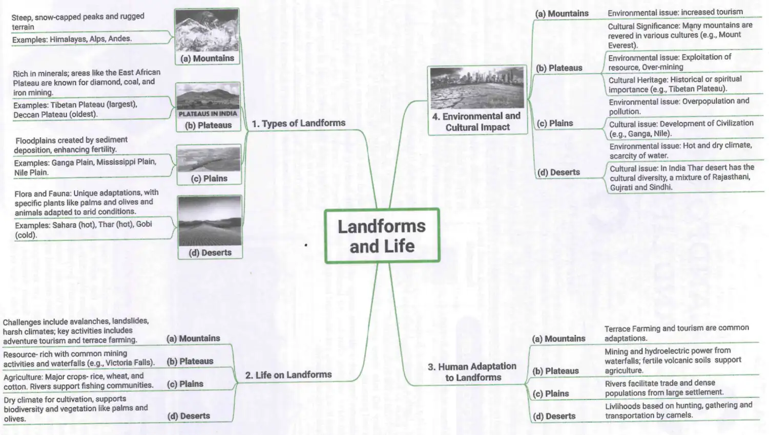
This mind map explains four main landforms (Mountains, Plateaus, Plains, Deserts) and covers their types, life on them, human adaptation, and environmental & cultural impacts.
Don’t Miss Out
- Bachendri Pal started climbing mountains from a young age and led many women’s climbing expeditions. She was the first Indian woman to climb Mount Everest in 1984 and was awarded Padma Shri the same year (and Padma Bhushan in 2019).
- Arunima Sinha lost a leg in an accident when she was 31. With Bachendri Pal’s encouragement and training, she managed to climb Mount Everest in 2013, and went on to climb the highest peak of every continent, including Mount Vinson in Antarctica! She was awarded Padma Shri in 2015.
- The Tibetan Plateau has an average altitude of 4,500 m, which explains why it has been nicknamed the ‘Roof of the World’. From east to west, it is nearly 2,500 km long—the distance from Chandigarh to Kanyakumari.
- The Deccan Plateau of central and south India is one of the oldest plateaus in the world, formed through volcanic activity millions of years ago.
Plateaus
A plateau is a type of landform that rises from the surrounding area and has a relatively level surface, with steep slopes on some of its sides. Plateaus can be young or old in relation to Earth’s history, just like mountains. The Deccan Plateau and the Tibetan Plateau, which is the world’s largest and highest plateau, are two examples of plateaus. Plateaus can range in height from a few hundred metres to several thousand metres.
Plateaus are referred to be “storehouses of minerals” due to their abundance of mineral deposits.
Moreover, there are a lot of breathtaking waterfalls on plateaus. A few examples of these waterfalls are the Jog Falls on the Sharavati River in the Western Ghats, the Hundru Falls on the Subarnarekha River in the Chhota Nagpur Plateau, and the Victoria Falls on the Zambezi River in southern Africa. The Nohkalikai Falls, located in Meghalaya, descend 340 m from the Cherrapunji Plateau.
Exam Question
Q: What are the characteristics of plateaus and name some famous plateaus and waterfalls?
A: Plateaus have a relatively level surface with steep slopes on some sides. Famous plateaus include the Deccan Plateau and Tibetan Plateau. Notable waterfalls are Jog Falls, Hundru Falls, Victoria Falls, and Nohkalikai Falls.
Plains
Landforms with a large, level surface or one that slopes gradually are called plains. There aren’t any big hills or deep valleys in them. Typically, they are no more than 300 m above sea level.
The earliest civilisation emerged on fertile plains around rivers thousands of years ago. Over 40 crore people, or over 25% of India’s total population, reside on the Ganga plain, often known as the “Gangetic plain”. Plains offer a wide range of economic activity due to their gradual slope, which facilitates easy river navigation.
Exam Question
Q: What are plains and why are they important for human settlement?
A: Plains are large, level or gently sloping landforms with no big hills or valleys, usually below 300 m elevation. They are important because fertile soil and easy river navigation support agriculture and large populations, such as on the Gangetic plain.
Deserts
Generally speaking, deserts are thought to be vast, arid regions with minimal precipitation. They also have distinctive wildlife and plants. Certain deserts, such as the Thar Desert in the northwest of the Indian subcontinent and the Sahara Desert in Africa, are extremely hot. Some are chilly, such as Asia’s Gobi Desert. As for the continent of Antarctica, some experts also refer to it as a desert.
The varied wildlife found in deep forests, flowing rivers, lakes, grasslands and mountain caves includes the golden eagle, peregrine falcon, Canadian lynx, snow leopard, ibex, Himalayan thar, mountain hare, yak, grey fox, and black bear.
The greatest river that rises in the Himalayas is known in India as the “Ganga”. Steps are carved into the slope to practice cultivation on the slopes. We refer to this practice as terrace farming. Herding is the favoured vocation over agriculture in many hilly regions of the world. Often, tourism is a major source of revenue for the locals. For those who live in the highlands, tourism frequently provides a significant source of income.
Exam Question
Q: What are deserts and how do people adapt to living in mountainous and highland areas?
A: Deserts are vast, dry regions with little precipitation and special plants and animals. People in mountainous areas practice terrace farming and herding, and tourism often provides income.
Keywords
- Precipitation: Water from the atmosphere reaching the ground in any form – rain, snow and hail are the most common forms of precipitation.
- Altitude: The height of an object above sea level.
- Montane forest: A type of forest that grows in mountainous regions.
- Moss: A small green plant without flowers or true roots, often spreading in a cushion-like cover.
- Lichen: A plant-like organism that generally clings to rocks, walls or trees.
- Terrain: A piece or stretch of land, from the point of view of its physical features.
- Valley: A lower area between hills or mountains, often with a river or stream flowing through it.
- Flash flood: A sudden local flood, often caused by a cloudburst.
- Landslide: The sudden collapse of a mass of earth or rock from a mountainside.
- Avalanche: The sudden fall of snow, ice or rocks from a mountainside; often occurs when the snow starts melting.
- Cloudburst: A sudden violent rainstorm.
- Sea level: The average level of the surface of the oceans, also called ‘mean sea level’.
- Sediments: Floodplains are one type of plains formed by rivers originating in mountain ranges, where they collect particles of rock, sand and silt called sediments.
- Resilience: The capacity to meet challenges and difficulties, adapt to them or overcome them.
- Confluence: The meeting point of two or more rivers.
Solved Examples
Example 1
Question: Explain how glaciers shape mountain valleys.
Answer: Glaciers form when snow compresses into ice and slowly moves downhill due to gravity. As they move, glaciers scrape and erode the land beneath, carving out deep U-shaped valleys. They carry rocks and debris that shape the valley sides and floor. When glaciers melt, they leave behind fertile soil.
Example 2
Question: Why are plateaus called “storehouses of minerals”?
Answer: Plateaus often contain abundant mineral deposits formed over millions of years, making them rich sources of minerals. This is why they are called “storehouses of minerals.”
Practice Set
Easy
- What is a landform?
- Name the three general categories of landforms.
- What is terrace farming?
Moderate
- Describe the characteristics of mountains.
- Explain why plains are important for human settlement.
- List two famous plateaus and one waterfall on each.
Challenging
- Explain how glaciers contribute to the formation of valleys and fertile soil.
- Discuss the environmental and cultural impacts of mountains on human life.
- Compare and contrast deserts and plateaus in terms of climate and human adaptation.
Answer Key
Easy
- A landform is a geographic feature found on Earth’s surface.
- Plains, mountains, and plateaus.
- Terrace farming is carving steps into slopes to cultivate crops.
Moderate
- Mountains have a broad base, steep slopes, and a narrow summit; some are snow-capped.
- Plains have fertile soil and gentle slopes, supporting agriculture and large populations.
- Deccan Plateau (Jog Falls), Tibetan Plateau (Victoria Falls).
Challenging
- Glaciers erode land forming U-shaped valleys and leave fertile soil after melting.
- Mountains affect climate, support unique forests, and influence human activities like farming and tourism.
- Deserts are dry with sparse vegetation; plateaus are elevated flat areas rich in minerals; humans adapt differently to each.
Quick Reference
- Landforms: Plains, Mountains, Plateaus, Deserts
- Mountain Features: Broad base, steep slopes, snow-capped peaks
- Plateaus: Elevated flat land, mineral rich
- Plains: Flat or gently sloping land, fertile soil
- Deserts: Arid regions with special plants and animals
- Human Adaptations: Terrace farming, herding, mining, tourism
Glossary
- Precipitation
- Water from the atmosphere reaching the ground in any form – rain, snow and hail.
- Altitude
- The height of an object above sea level.
- Montane forest
- Forests that grow in mountainous regions.
- Moss
- A small green plant without flowers or true roots.
- Lichen
- A plant-like organism that clings to rocks, walls or trees.
- Terrain
- A stretch of land viewed by its physical features.
- Valley
- A low area between hills or mountains, often with a river.
- Flash flood
- A sudden local flood caused by heavy rain.
- Landslide
- The sudden collapse of earth or rock from a mountainside.
- Avalanche
- The sudden fall of snow, ice or rocks from a mountainside.
- Cloudburst
- A sudden violent rainstorm.
- Sea level
- The average level of the ocean surface.
- Sediments
- Particles of rock, sand and silt deposited by rivers.
- Resilience
- The capacity to adapt to or overcome challenges.
- Confluence
- The meeting point of two or more rivers.