CLASS 11-HUMANITIES . GEOGRAPHY . INDIA PHYSICAL ENVIRONMENT . STRUCTURE AND-PHYSIOGRAPHY
Chapter 2 : Structure And Physiography
Ch 2
GEOGRAPHY
CLASS 11-HUMANITIES
Structure and Physiography
India's physical geography is divided into several distinct regions, each with unique characteristics. These include the Northern and North-Eastern Mountains, Islands, Indian Desert, Coastal Plains, Peninsular Plateau, Central Highlands, and Deccan Plateau. Understanding these regions helps in comprehending the diverse physiographic features of India.
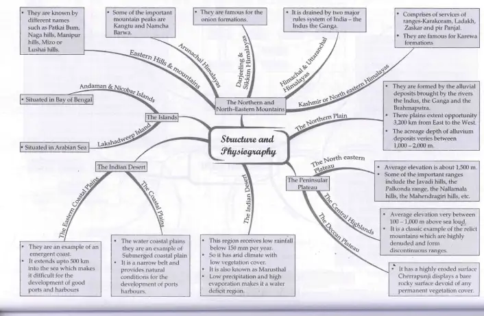
The Northern and North-Eastern Mountains
The Northern and North-Eastern Mountains include the Himalayas and the North-Eastern hills. The Himalayas consist of parallel ranges such as the Greater Himalayas, Middle Himalayas, and Shiwalik range. These mountains are young, tectonic in origin, and characterized by features like gorges, V-shaped valleys, rapids, and waterfalls. The region is a climatic, drainage, and cultural divide with significant regional variations.
Key sub-regions include:
- Kashmir or Northwestern Himalayas: Includes ranges like Karakoram, Ladakh, Zaskar, and Pir Panjal. Features the Kashmir valley and Dal Lake.
- Himachal and Uttarakhand Himalayas: Lies between the Ravi and Kali rivers, drained by tributaries of the Indus and Ganga rivers. Notable for Shiwalik and Dun formations.
- Darjiling and Sikkim Himalayas: Flanked by Nepal and Bhutan Himalayas, inhabited by diverse ethnic groups.
- Arunachal Himalayas: Extends eastward with important peaks like Kangtu and Namcha Barwa, home to various tribal communities practicing shifting cultivation.
- Eastern Hills and Mountains: Includes Patkai Bum, Naga hills, Manipur hills, and Mizo hills, with unique river systems and physiography.
Exam Questions
Q1: What are the main characteristics of the Himalayas?
A1: The Himalayas are young, tectonic mountains with parallel ranges, featuring gorges, V-shaped valleys, and waterfalls. They act as a physical, climatic, and cultural divide with significant regional variations.
Q2: Name the important mountain ranges in the Kashmir Himalayas.
A2: Karakoram, Ladakh, Zaskar, and Pir Panjal ranges.
The Northern Plains
The Northern Plains are formed by alluvial deposits from the Indus, Ganga, and Brahmaputra rivers. Extending about 3,200 km east to west, these plains have an average width of 150-300 km and alluvium depth of 1,000-2,000 meters. The plains are divided into three zones from north to south: Bhabar, Tarai, and alluvial plains, with the latter further divided into Khadar and Bhangar.
The plains are fertile and support intensive agriculture, growing crops like wheat, rice, sugarcane, and jute.
Exam Questions
Q1: What are the divisions of the Northern Plains based on physiography?
A1: The Northern Plains are divided into Bhabar, Tarai, and alluvial plains, with the alluvial plains further divided into Khadar and Bhangar.
Q2: Why are the Northern Plains important for agriculture?
A2: Due to fertile alluvial soil deposited by rivers, the plains support a variety of crops and sustain a large population.
The Peninsular Plateau
The Peninsular Plateau is an ancient, stable landmass rising from 150 m to 600-900 m above sea level, shaped by ancient gneisses and granites. It includes various plateaus such as Hazaribagh, Palamu, Ranchi, Malwa, Coimbatore, and Karnataka plateaus. The plateau features tors, block mountains, rift valleys, spurs, and quartzite dykes.
It is divided into three broad groups:
- Deccan Plateau: Bordered by Western Ghats, Eastern Ghats, and Satpura ranges. Western Ghats are higher and more continuous than Eastern Ghats.
- Central Highlands: Bounded by the Aravali range and includes Satpura and Maikal ranges. The region has metamorphic rocks and slopes northward.
- Northeastern Plateau: Includes Meghalaya and Karbi Anglong plateaus, detached from the main Peninsular block due to faulting.
Exam Questions
Q1: What are the main features of the Peninsular Plateau?
A1: It is an ancient, stable landmass with plateaus, hills, tors, block mountains, and rift valleys. It is divided into Deccan Plateau, Central Highlands, and Northeastern Plateau.
Q2: Name the two major mountain ranges bordering the Deccan Plateau.
A2: Western Ghats and Eastern Ghats.
The Indian Desert, The Coastal Plains, and The Islands
The Indian Desert, also known as Marusthali, lies northwest of the Aravali Hills. It has undulating topography with dunes and barchans, receives less than 150 mm rainfall annually, and has arid climate with sparse vegetation. Rivers are mostly ephemeral, with the Luni river being significant.
The Coastal Plains are divided into Western and Eastern coastal plains. The Western coastal plains are narrow, submerged, and have many natural ports like Kandla and Mumbai. The Eastern coastal plains are broader, emergent coasts with well-developed deltas but fewer good ports due to a wide continental shelf.
India has two major island groups: the Andaman and Nicobar Islands in the Bay of Bengal, and the Lakshadweep Islands in the Arabian Sea. The Andaman and Nicobar Islands are volcanic and mountainous, while Lakshadweep is coral-based.
Exam Questions
Q1: What are the characteristics of the Indian Desert?
A1: It has undulating topography with dunes, receives very low rainfall, has arid climate, sparse vegetation, and mostly ephemeral rivers.
Q2: How do the Western and Eastern coastal plains differ?
A2: Western coastal plains are narrow and submerged with many natural ports; Eastern coastal plains are broader, emergent with well-developed deltas but fewer ports due to a wide continental shelf.
Solved Examples
Example 1: Explain the significance of the Himalayas in India's geography.
Solution: The Himalayas act as a physical barrier protecting India from cold Central Asian winds, influence the monsoon climate, are the source of major rivers, and form a cultural and ecological divide.
Example 2: Describe the formation and features of the Northern Plains.
Solution: The Northern Plains were formed by alluvial deposits from the Indus, Ganga, and Brahmaputra rivers. They are fertile, support dense population, and are divided into Bhabar, Tarai, Khadar, and Bhangar zones based on soil and physiography.
Practice Set
Easy
- What are the main mountain ranges of the Himalayas?
- Define the term 'physiography'.
Moderate
- Explain the differences between the Western and Eastern Ghats.
- Describe the characteristics of the Indian Desert.
Challenging
- Discuss the geological significance of the Peninsular Plateau.
- Explain the formation and importance of the Northern Plains in India.
Answer Key
- Easy 1: Greater Himalayas, Middle Himalayas, and Shiwalik ranges.
- Easy 2: Physiography is the study of physical features of the earth's surface and their formation.
- Moderate 1: Western Ghats are higher, continuous, and wetter; Eastern Ghats are lower, discontinuous, and more eroded.
- Moderate 2: Indian Desert has low rainfall, arid climate, dunes, sparse vegetation, and ephemeral rivers.
- Challenging 1: The Peninsular Plateau is one of the oldest landmasses, stable, with diverse landforms like plateaus, hills, and rift valleys, important for mineral resources and river origins.
- Challenging 2: Northern Plains formed by river alluvium, fertile, support agriculture and dense population, divided into Bhabar, Tarai, Khadar, and Bhangar zones.
Quick Reference
- Himalayas: Young, tectonic mountains with parallel ranges.
- Northern Plains: Fertile alluvial plains formed by Indus, Ganga, Brahmaputra.
- Peninsular Plateau: Ancient stable landmass with plateaus and hills.
- Indian Desert: Arid region with dunes and low rainfall.
- Coastal Plains: Western (narrow, submerged) and Eastern (broad, emergent).
- Islands: Andaman & Nicobar (volcanic), Lakshadweep (coral).
Glossary
- Physiography
- The study of physical features of the earth's surface and their formation.
- Alluvium
- Soil or sediments deposited by rivers.
- Plateau
- An elevated flat landform.
- Dunes
- Hills of sand formed by wind action.
- Emergent Coast
- A coastline rising above sea level due to geological uplift.
- Submerged Coast
- A coastline submerged below sea level due to sea level rise or land subsidence.
- Ephemeral River
- A river that flows only during certain seasons or after rainfall.
- Shifting Cultivation
- A form of agriculture where land is cleared by slashing and burning and cultivated temporarily.
Chronology of Major Physiographic Events in India
| Time Period / Year | Event / Change | Importance |
|---|---|---|
| Millions of years ago | Indian Plate located south of the Equator | Formation of Peninsular Block and subsequent northward movement |
| About 64 million years ago | Formation of Indo-Ganga-Brahmaputra Plain during Himalayan orogeny | Creation of fertile alluvial plains supporting agriculture |
| Recent geological times | Formation of Himalayas and North-Eastern hills | Physical barrier, climatic and cultural divide |
| Present | Ongoing northward movement of Indian Plate | Continued tectonic activity affecting landscape and seismicity |