CLASS 11-HUMANITIES . GEOGRAPHY . FUNDAMENTAL OF PHYSICAL GEOGRAPHY . LANDFORMS AND-THEIR-EVOLUTION
Chapter 6 : Landforms And Their Evolution
Ch 6
GEOGRAPHY
CLASS 11-HUMANITIES
Landforms and Their Evolution
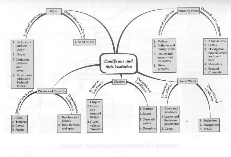
Landforms are natural features of the earth's surface, shaped by various geomorphic agents such as wind, running water, waves and currents, glaciers, and groundwater. These agents cause erosion (wearing away of earth materials) and deposition (accumulation of sediments), leading to the formation and evolution of diverse landforms. Understanding these processes helps explain how the earth's surface changes over time.
Exam Question
Q: What are the main natural forces responsible for the formation of landforms?
A: The main natural forces shaping landforms are wind, running water, waves and currents, glaciers, and groundwater.
Running Water: Erosional and Depositional Landforms
Running water is a major geomorphic agent, especially in humid regions with heavy rainfall. It acts through overland flow and streams or rivers, causing erosion and deposition that shape the land surface over time.
Erosional Landforms:
- Valleys: Formed by the gradual deepening and widening of rills and gullies into V-shaped valleys, gorges, or canyons depending on rock type and structure.
- Potholes and Plunge Pools: Circular depressions formed by the abrasive action of rotating pebbles and boulders in stream beds and at waterfall bases.
- Incised or Entrenched Meanders: Deep, winding river bends cut into hard rock, formed by lateral erosion on gentle slopes.
- River Terraces: Old valley floors or floodplains formed by vertical erosion and deposition, appearing as step-like features along river valleys.
Depositional Landforms:
- Alluvial Fans: Cone-shaped deposits formed where streams lose velocity on gentler slopes, dropping coarse sediments.
- Deltas: Deposits at river mouths where sediment accumulates in the sea, forming stratified, well-sorted landforms.
- Floodplains, Natural Levees, and Point Bars: Flat areas formed by sediment deposition during floods; levees are raised banks along rivers, and point bars are sediment deposits on the inside bends of meanders.
- Meanders: Loop-like bends in rivers caused by erosion on the outer banks and deposition on the inner banks.
- Braided Channels: Networks of river channels separated by sediment bars, formed when rivers carry coarse material and deposit it selectively.
Exam Question
Q: How do alluvial fans and deltas differ in their formation?
A: Alluvial fans form where streams deposit coarse sediments on land at the base of mountains, while deltas form where rivers deposit sediments at their mouths into the sea.
Groundwater: Erosional and Depositional Landforms
Groundwater moves through permeable rocks and causes erosion mainly by solution, especially in limestone and dolomite regions, leading to distinctive landforms known as Karst topography.
Erosional Landforms:
- Sinkholes: Circular depressions formed by the dissolution of limestone, varying in size and depth.
- Lapiés and Limestone Pavements: Grooved and fluted limestone surfaces formed by differential solution along joints.
- Caves and Tunnels: Underground voids formed by groundwater erosion, sometimes with openings at one or both ends.
Depositional Landforms:
- Stalactites: Icicle-shaped deposits hanging from cave ceilings formed by dripping water depositing calcium salts.
- Stalagmites: Column-like deposits rising from cave floors formed by dripping water.
- Pillars: Formed when stalactites and stalagmites join together.
Exam Question
Q: What is Karst topography and how is it formed?
A: Karst topography is a landscape formed in limestone or dolomite regions by the action of groundwater through solution and deposition, resulting in features like sinkholes, caves, and limestone pavements.
Glaciers: Erosional and Depositional Landforms
Glaciers are large masses of ice that move under gravity, eroding and depositing materials to shape the landscape, especially in mountainous and polar regions.
Erosional Landforms:
- Cirques: Bowl-shaped depressions at the heads of glacial valleys formed by ice accumulation and erosion.
- Horns and Serrated Ridges: Sharp peaks and ridges formed by the headward erosion of multiple cirques.
- Glaciated Valleys (U-shaped Valleys): Broad, trough-like valleys with steep sides formed by glacier movement.
- Fjords: Deep glacial valleys filled with seawater, forming steep coastal inlets.
Depositional Landforms:
- Moraines: Ridges of debris deposited at glacier edges or ends, including terminal, lateral, and ground moraines.
- Eskers: Long, winding ridges formed by sediment deposition from streams flowing beneath glaciers.
- Outwash Plains: Broad plains formed by meltwater deposits beyond glacier limits.
- Drumlins: Smooth, oval-shaped hills composed of glacial till, indicating glacier movement direction.
Exam Question
Q: What are moraines and how do they form?
A: Moraines are ridges of debris deposited by glaciers at their edges or ends, formed from materials carried and dropped by the moving ice.
Waves and Currents: Erosional and Depositional Landforms
Waves and currents constantly shape coastal landscapes through erosion and deposition, influencing the formation of cliffs, beaches, and other coastal features.
Erosional Landforms:
- Cliffs and Wave-cut Terraces: Steep rock faces and flat platforms formed by wave erosion at the base of cliffs.
- Caves and Sea Stacks: Caves form by wave erosion of weak rock zones; sea stacks are isolated rock columns left after cliff retreat.
Depositional Landforms:
- Beaches: Accumulations of sand or pebbles along shorelines formed by wave deposition.
- Bars, Barrier Bars, and Spits: Ridges of sand or shingle formed offshore or extending from the coast, shaped by wave and current action.
Exam Question
Q: How do sea stacks form along rocky coasts?
A: Sea stacks form when waves erode parts of cliffs, creating caves that eventually collapse, leaving isolated rock columns offshore.
Wind: Erosional and Depositional Landforms
Wind is a dominant geomorphic agent in arid and semi-arid regions, causing erosion through deflation and abrasion, and deposition forming various desert landforms.
Erosional Landforms:
- Pediments and Pediplains: Gently sloping rocky surfaces at mountain bases formed by wind erosion.
- Deflation Hollows and Caves: Shallow depressions and cavities formed by wind removing loose particles.
- Mushroom, Table, and Pedestal Rocks: Rock formations shaped by wind abrasion, with narrow bases and wider tops.
Depositional Landforms:
- Sand Dunes: Mounds or ridges of sand formed by wind deposition, with various shapes such as barchans, parabolic, seif, longitudinal, and transverse dunes.
Exam Question
Q: What are barchan dunes and where do they form?
A: Barchan dunes are crescent-shaped sand dunes with horns pointing downwind, formed in deserts where wind direction is constant and sand supply is limited.
Solved Examples
- Example: Explain how a V-shaped valley is formed by running water.
Solution: Running water erodes the land by cutting downwards into the earth's surface, forming narrow, steep-sided valleys with a V shape due to the downward erosion and weathering of valley sides.
- Example: Describe the formation of stalactites and stalagmites.
Solution: Stalactites form when calcium-rich water drips from cave ceilings, depositing calcium carbonate as icicle-shaped formations. Stalagmites form on the cave floor from dripping water deposits, often growing upwards to meet stalactites.
Practice Set
Easy
- What is a landform?
- Name two erosional landforms created by running water.
Moderate
- Explain the difference between alluvial fans and deltas.
- What are moraines and how are they formed?
Challenging
- Describe the process of formation of Karst topography and name its key features.
- How do waves contribute to the formation of sea stacks and wave-cut terraces?
Answer Key
- A landform is a small to medium tract or parcel of the earth's surface with distinct physical shape and size.
- Valleys and potholes are erosional landforms created by running water.
- Alluvial fans form on land at mountain bases from coarse sediment deposition; deltas form at river mouths in the sea from well-sorted sediment deposits.
- Moraines are ridges of debris deposited by glaciers at their edges or ends.
- Karst topography forms by groundwater solution and deposition in limestone regions, featuring sinkholes, caves, and limestone pavements.
- Waves erode cliff bases forming caves; continued erosion causes cliff retreat leaving isolated rock columns called sea stacks; wave-cut terraces are flat platforms formed by wave erosion at cliff bases.
Quick Reference
- Landforms: Natural features shaped by erosion and deposition.
- Running Water: Forms valleys, potholes, alluvial fans, deltas.
- Groundwater: Creates Karst features like sinkholes, caves, stalactites.
- Glaciers: Form cirques, moraines, eskers, drumlins.
- Waves and Currents: Shape cliffs, beaches, sea stacks, bars.
- Wind: Forms dunes, pediments, deflation hollows.
Glossary
- Alluvial Fan
- A cone-shaped deposit of sediment formed where a stream slows down on a plain.
- Delta
- A landform at a river mouth formed by sediment deposition into a sea or lake.
- Karst Topography
- Landscape formed by the dissolution of soluble rocks like limestone.
- Moraines
- Accumulations of debris deposited by glaciers.
- Pediment
- Gently sloping rock surface at the base of mountains in deserts.
- Stalactite
- Icicle-shaped deposit hanging from cave ceilings.
- Stalagmite
- Column-shaped deposit rising from cave floors.
- U-shaped Valley
- Glacially carved valley with a broad floor and steep sides.
Chronology of Landform Formation
| Time Period / Stage | Event / Change | Importance |
|---|---|---|
| Early Stage of River Development | Formation of shallow V-shaped valleys, few streams, waterfalls present | Initial erosion and valley formation |
| Middle Stage | Deepening of valleys, increased stream integration, wider floodplains | Active erosion and deposition balance |
| Old Stage | Gentle gradients, meandering streams, extensive floodplains | Dominance of deposition, mature landscape |
| Glacial Periods | Glacier advance and retreat forming cirques, moraines, drumlins | Major reshaping of mountainous terrain |
| Post-Glacial | Formation of outwash plains, eskers, and fjords | Deposition and sea level changes |