CLASS 11-HUMANITIES . GEOGRAPHY . FUNDAMENTAL OF PHYSICAL GEOGRAPHY . INTERIOR OF-THE-EARTH
Chapter 3 : INTERIOR OF THE EARTH
Ch 3
GEOGRAPHY
CLASS 11-HUMANITIES
Interior of the Earth
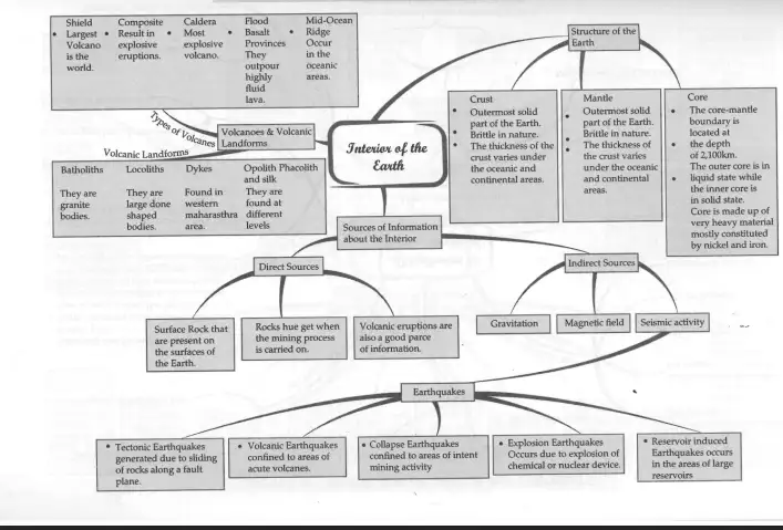
The Earth is composed of three main layers: the crust, mantle, and core. The crust is the outermost solid layer, brittle in nature, with varying thickness—about 5 km under oceans and 30 km under continents. Beneath the crust lies the mantle, which is solid but behaves plastically in some parts. The upper mantle includes the asthenosphere, a weaker zone extending up to 400 km depth. Together, the crust and uppermost mantle form the lithosphere, ranging from 10 to 200 km thick. The core lies beneath the mantle, divided into a liquid outer core and a solid inner core, primarily composed of nickel and iron.
Volcanic landforms arise from the movement of magma and lava. Types include batholiths (large magmatic domes formed deep in the crust), laccoliths (dome-shaped intrusive bodies), dykes (vertical wall-like intrusions), and phacoliths (wavy masses of intrusive rocks at fold bases). Volcanoes vary as shield volcanoes (large, fluid basaltic lava flows), composite volcanoes (explosive eruptions with viscous lava), caldera volcanoes (collapse structures after massive eruptions), flood basalts (extensive lava flows), and mid-ocean ridge volcanoes (undersea volcanic activity along oceanic ridges).
Scientists study the Earth's interior through direct sources like surface and underground rocks, volcanic eruptions, and meteorites, and indirect sources such as gravitational and magnetic fields, and seismic activity. Earthquakes result from energy release within the Earth, generating waves recorded by seismographs. These waves include body waves (P-waves and S-waves) and surface waves, with phenomena like shadow zones where waves are not detected. Earthquakes are classified by causes: tectonic, volcanic, collapse, explosion, and reservoir-induced.
Sources of Information about the Interior, Earthquake and its Effects
Understanding the Earth's interior is essential to explain surface phenomena like earthquakes and tsunamis. Direct information comes from surface rocks, mining, deep ocean drilling projects, and volcanic eruptions. Meteorites provide comparative material but not direct Earth interior samples. Indirect methods include studying gravity anomalies, magnetic fields, and seismic waves.
Earthquakes are natural shaking events caused by energy release at a focus (hypocentre), with the epicentre being the surface point above it. Seismographs record earthquake waves, which include fast-moving primary (P) waves and slower secondary (S) waves. Wave reflection and refraction help infer Earth's internal structure. Shadow zones are areas where certain seismic waves are not detected.
Types of earthquakes include tectonic (due to fault movements), volcanic (near active volcanoes), collapse (mine roof failures), explosion (chemical or nuclear blasts), and reservoir-induced (due to large water bodies). The Richter Scale measures earthquake magnitude. Tsunamis are waves generated by seismic activity but are not earthquakes themselves.
Exam Questions
Q1: What are the direct and indirect sources of information about the Earth's interior?
A1: Direct sources include surface rocks, mining samples, volcanic eruptions, and meteorites. Indirect sources are gravitational and magnetic field studies and seismic wave analysis.
Q2: Define the focus and epicentre of an earthquake.
A2: The focus (hypocentre) is the point inside the Earth where an earthquake originates. The epicentre is the point on the Earth's surface directly above the focus.
Structure of the Earth, Volcanoes and Volcanic Landforms
The Earth's crust varies in thickness, thinner under oceans and thicker under continents. The mantle beneath includes the asthenosphere, a weak zone allowing lithospheric movement. The core is dense and metallic, with a liquid outer and solid inner part.
Volcanoes are openings where gases, ash, and lava escape. Active volcanoes have recent eruptions. Magma is molten rock beneath the surface; when it reaches the surface, it is called lava. Different volcano types include shield volcanoes (fluid basaltic lava), composite volcanoes (explosive eruptions), calderas (collapsed volcanoes), flood basalts (extensive lava flows), and mid-ocean ridge volcanoes (undersea volcanic activity).
Volcanic landforms include batholiths (large intrusive domes), laccoliths (dome-shaped intrusions), sills (horizontal intrusions), lapoliths (saucer-shaped intrusions), dykes (vertical intrusions), and phacoliths (wavy intrusive masses in folded regions).
Exam Questions
Q1: What is the difference between magma and lava?
A1: Magma is molten rock beneath the Earth's surface; lava is magma that has reached the surface.
Q2: Name and describe two types of volcanic landforms.
A2: Batholiths are large bodies of cooled magma forming domes deep in the crust. Dykes are vertical wall-like intrusions formed when magma solidifies in cracks.
Solved Examples
Example 1: Explain how seismic waves help in understanding the Earth's interior.
Solution: Seismic waves generated by earthquakes travel through the Earth and are recorded by seismographs. P-waves and S-waves travel at different speeds and through different materials, and their reflection and refraction patterns reveal the structure and composition of Earth's layers.
Example 2: Describe the characteristics of shield and composite volcanoes.
Solution: Shield volcanoes have gentle slopes and erupt fluid basaltic lava, forming large landforms. Composite volcanoes have steeper slopes, erupt viscous lava, and often produce explosive eruptions.
Practice Set
Easy
- What are the three main layers of the Earth?
- Define the Richter Scale.
Moderate
- Explain the difference between P-waves and S-waves.
- What is the asthenosphere and why is it important?
Challenging
- Describe the formation and types of volcanic landforms.
- Discuss the sources of information about the Earth's interior and their significance.
Answer Key
- Three main layers: crust, mantle, core.
- Richter Scale measures earthquake magnitude.
- P-waves are primary, faster waves that travel through solids, liquids, and gases; S-waves are secondary, slower waves that travel only through solids.
- The asthenosphere is the weak, ductile part of the upper mantle that allows lithospheric plates to move.
- Volcanic landforms form from magma/lava movement; types include batholiths, laccoliths, dykes, shield volcanoes, composite volcanoes, calderas, etc.
- Information sources include direct observations (rocks, volcanic eruptions) and indirect methods (seismic waves, gravity, magnetic fields), essential for understanding Earth's structure.
Quick Reference
- Crust: Outermost solid layer, 5-30 km thick.
- Mantle: Solid layer beneath crust, includes asthenosphere.
- Core: Inner metallic layer, liquid outer and solid inner parts.
- Volcano: Opening for magma/lava and gases.
- Earthquake: Shaking caused by energy release inside Earth.
- Seismic Waves: P-waves (primary), S-waves (secondary), surface waves.
- Richter Scale: Measures earthquake magnitude.
Glossary
- Asthenosphere: Weak, ductile upper mantle layer.
- Batholith: Large intrusive magmatic dome.
- Dyke: Vertical intrusion of solidified magma.
- Epicentre: Surface point above earthquake focus.
- Focus (Hypocentre): Point inside Earth where earthquake originates.
- Laccolith: Dome-shaped intrusive body.
- Magma: Molten rock beneath Earth's surface.
- Lava: Magma that reaches Earth's surface.
- Phacolith: Wavy intrusive rock mass in folded regions.
- Richter Scale: Scale measuring earthquake magnitude.
- Shadow Zone: Area where seismic waves are not detected.
- Seismograph: Instrument recording earthquake waves.
| Time Period / Year | Event / Change | Importance |
|---|---|---|
| Ongoing | Deep Ocean Drilling Project and Integrated Ocean Drilling Project | Provide direct samples and data about Earth's crust and mantle. |
| Various | Volcanic eruptions | Provide direct material (lava, ash) for analysis of Earth's interior. |
| Historical | Development of seismographs | Enabled recording and study of earthquake waves to understand Earth's structure. |
| 20th Century | Introduction of Richter Scale | Standardized measurement of earthquake magnitude. |