CLASS 11-HUMANITIES . GEOGRAPHY . FUNDAMENTAL OF PHYSICAL GEOGRAPHY . ATMOSPHERIC CIRCULATION-AND-WEATHER-SYSTEMS
Chapter 9 : Atmospheric Circulation And Weather Systems
Ch 9
GEOGRAPHY
CLASS 11-HUMANITIES
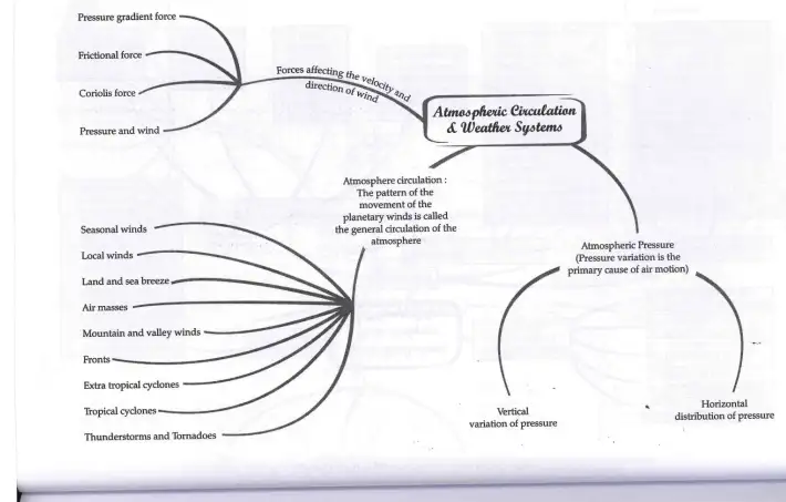
Atmospheric Pressure and Forces Affecting Wind
Atmospheric pressure is the weight of a column of air above a unit area extending from sea level to the top of the atmosphere. It is measured in millibars (mb) using instruments like the mercury barometer or aneroid barometer. Atmospheric pressure decreases with altitude and varies horizontally, causing air to move from high-pressure to low-pressure areas, generating wind.
Vertical pressure gradient force is stronger than horizontal pressure gradient force. Horizontal pressure variations are studied using isobars, lines connecting points of equal pressure. Key pressure belts include the equatorial low near the equator, subtropical highs around 30° N and S, subpolar lows near 60° N and S, and polar highs near the poles. These belts shift seasonally with the sun's apparent movement.
Wind is air in motion influenced by three main forces:
- Pressure Gradient Force: Drives air from high to low pressure.
- Frictional Force: Resists wind motion, strongest near the surface and diminishing with altitude.
- Coriolis Force: Caused by Earth's rotation, deflects wind direction to the right in the Northern Hemisphere and to the left in the Southern Hemisphere; strongest at poles and zero at the equator.
At higher altitudes (2-3 km above surface), winds called geostrophic winds blow parallel to isobars due to balance between pressure gradient and Coriolis forces. Wind circulation around low-pressure areas is cyclonic, and around high-pressure areas is anticyclonic, with directions varying by hemisphere.
Exam Questions
Q1: What causes wind to blow from one place to another?
A1: Wind blows due to differences in atmospheric pressure, moving from high-pressure to low-pressure areas.
Q2: Name the three forces that affect wind velocity and direction.
A2: Pressure gradient force, frictional force, and Coriolis force.
Q3: What is the Coriolis force and how does it affect wind?
A3: Coriolis force is the deflection of moving air caused by Earth's rotation, causing winds to turn right in the Northern Hemisphere and left in the Southern Hemisphere.
General Circulation of the Atmosphere
The general circulation of the atmosphere refers to the large-scale movement of air that distributes heat and moisture around the Earth. It is influenced by latitudinal variation in solar heating, pressure belts, the distribution of continents and oceans, Earth's rotation, and the migration of pressure belts with the sun's apparent movement.
At the Inter Tropical Convergence Zone (ITCZ), warm air rises due to convection, creating a low-pressure zone where trade winds from both hemispheres converge. This rising air moves poleward at high altitudes, cools, and sinks around 30° latitude forming subtropical highs. Surface winds then flow back towards the equator as trade winds, completing the Hadley Cell circulation.
In mid-latitudes, the Ferrel Cell circulates air between subtropical highs and subpolar lows, with surface westerlies prevailing. Near the poles, the Polar Cell circulates cold dense air from polar highs towards subpolar lows as polar easterlies.
Local deviations include seasonal winds like monsoons, local winds such as land and sea breezes, mountain and valley winds, and various weather systems like air masses, fronts, cyclones, thunderstorms, and tornadoes.
Exam Questions
Q1: What causes the formation of the Inter Tropical Convergence Zone?
A1: The ITCZ forms due to intense solar heating at the equator causing air to rise and create a low-pressure zone where trade winds converge.
Q2: Name the three major atmospheric circulation cells.
A2: Hadley Cell, Ferrel Cell, and Polar Cell.
Q3: What are land and sea breezes?
A3: Land breeze is wind blowing from land to sea at night due to cooler land, and sea breeze is wind blowing from sea to land during the day due to warmer land.
Weather Systems and Local Winds
Weather systems include various types of winds and storms that affect local and regional climates. Seasonal winds like monsoons result from shifting pressure belts. Local winds arise from differential heating of land and water, such as land and sea breezes, and mountain and valley winds.
Air masses are large bodies of air with uniform temperature and humidity characteristics. When different air masses meet, they form fronts—boundaries that can be stationary, cold, warm, or occluded—leading to various weather phenomena.
Extra tropical cyclones develop in mid and high latitudes along polar fronts, causing abrupt weather changes. Tropical cyclones form over warm tropical oceans and are characterized by strong spiraling winds around a calm eye, causing heavy rainfall and destruction upon landfall.
Thunderstorms are intense convective storms producing thunder and lightning, often leading to tornadoes—violent rotating columns of air in contact with the ground and cumulonimbus clouds. Tornadoes over the sea are called waterspouts.
Exam Questions
Q1: What is a front in meteorology?
A1: A front is the boundary zone where two different air masses meet.
Q2: How do tropical cyclones differ from extra tropical cyclones?
A2: Tropical cyclones form over warm tropical oceans with high wind speeds and no frontal system, while extra tropical cyclones form in mid-latitudes with frontal systems and cover larger areas.
Q3: What causes land and sea breezes?
A3: Differential heating of land and sea causes pressure differences, leading to sea breeze during the day and land breeze at night.
Solved Examples
Example 1: Explain why wind direction changes with altitude.
Solution: Near the surface, wind direction is affected by friction, pressure gradient force, and Coriolis force, causing it to cross isobars at an angle. At higher altitudes, friction is negligible, and wind blows parallel to isobars due to balance between pressure gradient and Coriolis forces, known as geostrophic wind.
Example 2: Describe the formation of a tropical cyclone.
Solution: Tropical cyclones form over warm ocean waters above 27°C with sufficient Coriolis force, low vertical wind shear, and pre-existing low-pressure areas. Warm moist air rises, creating low pressure and spiraling winds around the eye, intensifying the storm.
Practice Set
Easy
- Define atmospheric pressure.
- What are isobars?
- What is the Coriolis force?
Moderate
- Explain the general circulation of the atmosphere.
- Describe the characteristics of the Hadley Cell.
- What causes land and sea breezes?
Challenging
- Compare and contrast tropical cyclones and extra tropical cyclones.
- Explain the role of pressure gradient, frictional, and Coriolis forces in wind movement.
- Describe the formation and types of fronts.
Answer Key
Easy:
- Atmospheric pressure is the weight of the air column above a unit area.
- Isobars are lines connecting points of equal atmospheric pressure.
- Coriolis force is the deflection of moving air due to Earth's rotation.
Moderate:
- General circulation is the large-scale movement of air distributing heat and moisture globally, involving Hadley, Ferrel, and Polar cells.
- Hadley Cell is a tropical circulation cell where warm air rises at the equator, moves poleward at high altitude, sinks at 30° latitude, and returns as trade winds.
- Land and sea breezes are caused by differential heating of land and sea, leading to pressure differences and wind flow.
Challenging:
- Tropical cyclones form over warm tropical oceans without frontal systems and have higher wind speeds; extra tropical cyclones form in mid-latitudes with frontal systems and cover larger areas.
- Pressure gradient force drives wind from high to low pressure; frictional force slows wind near the surface; Coriolis force deflects wind direction due to Earth's rotation.
- Fronts are boundaries between air masses; types include stationary, cold, warm, and occluded fronts, each with distinct weather patterns.
Quick Reference
- Atmospheric Pressure: Weight of air column above a point.
- Isobars: Lines of equal pressure.
- Pressure Belts: Equatorial low, subtropical highs, subpolar lows, polar highs.
- Forces on Wind: Pressure gradient, frictional, Coriolis.
- General Circulation Cells: Hadley, Ferrel, Polar.
- Local Winds: Land and sea breezes, mountain and valley winds.
- Weather Systems: Air masses, fronts, cyclones, thunderstorms, tornadoes.
Glossary
- Atmospheric Pressure
- Pressure exerted by the weight of air above a point.
- Isobars
- Lines connecting points of equal atmospheric pressure.
- Pressure Gradient Force
- Force causing air to move from high to low pressure.
- Frictional Force
- Force resisting wind motion near Earth's surface.
- Coriolis Force
- Deflection of moving air due to Earth's rotation.
- Hadley Cell
- Tropical atmospheric circulation cell between equator and 30° latitude.
- Ferrel Cell
- Mid-latitude atmospheric circulation cell between 30° and 60° latitude.
- Polar Cell
- Atmospheric circulation cell near the poles.
- Inter Tropical Convergence Zone (ITCZ)
- Low-pressure zone near the equator where trade winds converge.
- Air Mass
- Large body of air with uniform temperature and humidity.
- Front
- Boundary between two different air masses.
- Tropical Cyclone
- Violent storm originating over warm tropical oceans.
- Extra Tropical Cyclone
- Storm system forming in mid and high latitudes with frontal systems.
- Thunderstorm
- Storm with thunder, lightning, and heavy rain caused by convection.
- Tornado
- Violent rotating column of air in contact with ground and cumulonimbus cloud.
| Time Period / Year | Event / Change | Importance |
|---|---|---|
| Continuous | Formation of pressure belts (equatorial low, subtropical highs, subpolar lows, polar highs) | Determines global wind patterns and climate zones |
| Daily | Land and sea breeze cycle | Influences local weather near coasts |
| Seasonal | Shift of pressure belts and monsoon winds | Causes seasonal rainfall and temperature changes |
| During tropical cyclone season | Formation of tropical cyclones over warm oceans | Causes severe weather and damage in coastal areas |
| Mid-latitude seasons | Development of extra tropical cyclones | Brings abrupt weather changes in mid and high latitudes |